Ok, so unless they were trying to rendezvous with the secret undersea Nazi base on the underwater volcano, it looks like the "steal the airplane" thing either was wrong entirely or went completely awry.
As for scenarios, based on what CNN had on their screens I would say of the media, they have pretty much jumped the shark.
I am more and more interested in what steps international authorities will take with regards to requirements for commercial aircraft. We have the technology to prevent disappearances like this from occurring again, so will they step up and require them? The costs of the search must be pretty high by now
One of the scenarios, which has been credited as reasonable, is a big fire in the aircraft [1].
In the scenario depicted, "all the busses are pulled", in which case the airplane goes silent, then restored one by one, except that because of the fire, restoration hasn't been possible.
If that will prove to be the case, I think prevention measures would be quite hard - circuits were silenced.
I believe you nailed that one! And some people doubted the value of speculation on forums in terms of aiding the investigation :-)
People have explained on other threads that the pilot can pretty much turn off anything they want on board, so I'm not sure how you'd prevent that. Maybe they should have some kind of black-box-transponder thing that's self contained and cannot harm the aircraft even if, say, the circuitry were to catch on fire. Shrug... not my area of expertise by a long shot.
Apparently they almost do: the emergency transponder beacon at the back of the plane can be triggered by G force, and has its own battery. http://www.airliners.net/aviation-forums/general_aviation/re... That leads to the question of why this particular dog wasn't heard to bark when (and if) MH370 hit the water in the Indian Ocean, but that could probably be explained by assuming that the tail section sank fairly quickly: the beacon doesn't work underwater. But interestingly it also highlights what the Law of Unintended Consequences could do to self-powered, tamper-resistant systems: http://money.cnn.com/2013/07/18/news/dreamliner-fire-report/
You always have to assume that any device on the plane can be destroyed in an instant. Based on that assumption the real need is to detect loss of contact as quickly as possible and then respond to it in an appropriate and timely fashion. It is difficult to fuse data from hundreds of desperate sources into a coherent picture especially when they may be military.
I read somewhere around 5000 metres, double that of Air France 447. So if that is indeed the wreckage, it will take a while to recover the black boxes.
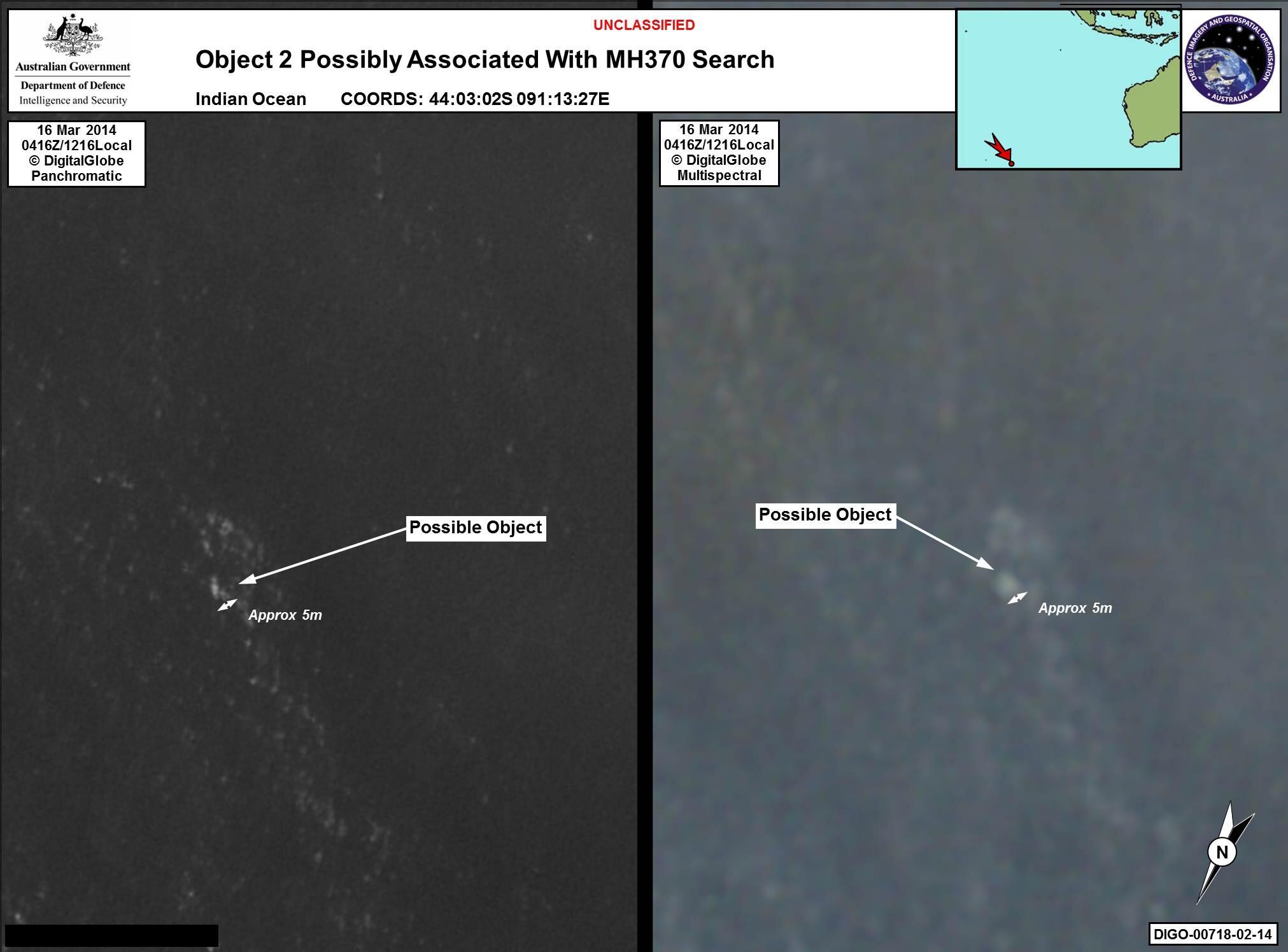
I am obviously no expert, but I expected something more clearer than this. This doesn't look too different from the smudges and discoloration all over the image (are those ocean waves?)
This is spot on. Most geointelligence is not based on a single photo, but a series of captures (multiple passes, wavelengths, angles, etc) and looking at what has or has not changed.
US intelligence agencies already have software that does multi-capture analysis like this, and I suspect it was the original source of this "discovery." Usually it is ran on small areas of the ocean (near military seaports or choke points in waterways) or is done at lower resolution to find big objects (aircraft carriers or cargo ships). The computational workload to find a sub-60 foot object in an entire ocean is mind blowing.
Right, the two images are off of two different sensors. Probably off the same satellite, one is a panchromatic image and one is probably one channel off of a multispectral sensor. The DTGs are the same (March 16th 2014, 4:16Zulu/12:16 Local).
For reference, DIGO is the Australian version of the U.S. NGA.
They probably have a bunch of analysts pulling long shifts staring at endless images of ocean along the suspected track.
The Jindalee over-the-horizon backscatter radar in Western Australia has the reach and resolution for detecting a chunk of metal that size on the surface.
Normally it searches for contacts in a programmed grid pattern, sort of a random-chance game of finding bad guys ( HF backscatter radars don't sweep like UHF radars with which we are more familiar ).
I'd hazard a guess that they programmed a radar search of the suspected area and when it found a contact they went and checked the satellite imagery. Spectroscopy from the image capture showed the object to be non-natural.
If it's an object that's still floating, it's more likely to be some sort of lightweight composite than metal. And if they are using this radar system in such a way, then they would presumably be able to use it to direct the search teams to the precise location in real time.
Jindalee is marvellous, but unfortunately ( AFAIK ) it isn't possible to use it in a general surveillance manner. It needs to be directed to a specific area which it monitors; this is partly dictated by HF propagation conditions.
Consider that it bounces its signal off the ionosphere to 'illuminate' an area on the surface. You can move that area around like a viewport but you can't make the viewport bigger.
If the MAS a/c didn't enter the areas they were monitoring that day then they wouldn't have contacted.
Presumably the idea is to scan the search area in a methodical (though not completely predictable) fashion, like destroyers trawling the North Atlantic for U-boats?
Yes, I think so! Or set-up a barrier-pattern of searching a linear range of areas continuously. I think they have four or five of these HF radars now, so they could co-operate.
At that time, nobody was looking for it. Unless you know to look out for something specific, it's just one more of the approximately 5,000 aircraft in the air at any one moment. Also these radars can have very narrow beam widths, typically half a degree. Suppose it was already being used for some other task?
With no active transponder MH370 would have been unidentified, and no communication with ATC would make it unannounced. It was also unexpected as there was no 'plane due to be in that area according to the filed flight plans (or every other one was identifiable).
Shouldn't this be quite easy to do with existing computer vision technology though (I'd assume this is a computer vision 101 class project)? Especially considering this is the ocean. The images were taken march 16nth, so they probably were running them through their software.
Depends on what you call 'quite easy'. In the terminology of http://fishbowl.pastiche.org/2007/07/17/understanding_engine... , it's still a 'hard' problem. There are tens of thousands if not an order of magnitude more objects and reflections of that size in the ocean.
It certainly is not a 'computer vision 101' project. 'Computer vision 101' is 'do edge detection using opencv', not 'build a complete system that interfaces near-realtime with satellite imagery sources that can do very detailed analysis, but without a real definition of what we're looking for, on huge amounts of data'.
Possibly. We don't really have a dataset of "images of crashed planes" for it to train on though. Perhaps you could use unsupervised learning to find images and image segments that are anomalous. However I expect you'd mostly get pictures of boats, planes, small islands, weird waves, floating garbage, etc. But that does significantly narrow down your search at least.
I´m just wild guessing here, but if the US had had the MH370 located with a classified radar or satellite, and they know it had crashed, It would be stupid to disclose that technology. They would better use available resources to point the actual position to the search teams (like: "look at this interesting satellite ping arc"), without showing that they knew the position all the time.
I´m not telling this is the actual case, but I would do it if I were the one in charge of such technology.
There's no evidence that they aren't being put to use. The ocean is big, just because one country's assets found something first doesn't mean others haven't been looking.
People associated with the US government seem to have been giddily feeding the NYT information and theories for days now. If anything the question seems to be how much of what they've been pushing is accurate.
Watched a mind-blowing TED talk by former NASA researcher Dan Berkenstock on the state of Satellite imagery and what we're going to be able to do in the next couple of years:
Would love to read more - could you track down the link?
It's interesting to think about the problem both from the perspective of the retailer AND from the perspective of the investor.
I mean a retailer can just look at their sales volume as an estimate for customer volume but obviously that data isn't available to outsiders.
One massive opportunity I've been swirling in my mind is what if you applied image recognition to counting foot traffic. Like if you could just point a webcam at a storefront and automatically count foot traffic - that would be very valuable information.
I just watched "All Is Lost" with Robert Redford, and I can't help but think that if you are going to have your boat sink in the Indian Ocean, now would be a REALLY good time to do it.
Distance between: 43:58:34S 090:57:37E 44:03:02S 091:13:27E
is 22.72km according to WolframAlpha
Images are from DigitalGlobe. A commercial satellite imagery / spatial data provider who provide a lot of imagery that powers Google Earth / Map. Also providing the imagery for the crowd-sourced effort for the search.
Just thinking out loud... but a piece that's 24m long, seems a bit small. To me it makes me think of a boat or something similar. I guess the news agencies are happy with this news today, at least they don't have to keep on repeating the fluff from the last few days.
I'd have thought that was the date of the image capture - surely it takes an immense amount of time to process that volume of imagery in order to pick out such a thing?
So there is a chance that from the time the image is taken till today it has drifted and the search area would again has to be widen around that location?
Even if you're not interested in planes or the souls on them, the technology deployed to find this needle in a large haystack is quite Hacker News-worthy.
A plane full of people vanished with no sign of wreckage nor anything to go on with tens of thousands of kilometres of possible search area. I'd say this is definitely "Hacker News worthy".
Actually, it's not even newsworthy. This is very similar to the live coverage of car chases that have no real news value - it is sensationalist journalism at it's worst. There are much bigger problems in the world. Heck, car accidents killed far more people in the US alone since this story began than were on that plane (30k/year means 82/day). And this is ignoring new revelations about technology companies being complicit in NSA spying - which is very Hacker News worthy.
The Crimean crisis is a good example of a news-worthy story that is absolutely not Hacker News-worthy.
It's interesting. 99% of the things on hacker news are insignificant and have little impact on the world. No one is saying that this plane is significant.
There's a very real chance that over 200 people were murdered in a single event - if that's not newsworthy anymore then that's a pretty fucking sad indictment of the state of the world.
Well I've been downvoted but this is what I'm talking about.
I am interested in this, I'm interesting in the technology, crowdsourcing and stuff to find the plane.
All I got was a jpg link to a person's dropbox, with no information about today's finding / sighting as opposed to yesterday's. Just a picture of a blob.
Yeah... and dropping bombs from robot airplanes is still a thing. I'm sorry for a lot of people who are missing their traveling loved ones, but this missing plane thing seems like a crazy distraction.
Hacker News seems to be a community of people who are good at solving problems. This is a big problem that needs solving. Over 200 people missing, all with families who are going through a terrible time. I think the HN response to this is a very positive thing.
Let's not groupthink our way into believing we are anything more than drivers who have slowed down in the opposite lane to rubberneck at a car crash at this point.
I´m finishing a blog post on how to use the satellite ping chain (with the consecutive position arcs) and the known cruise speed of the B777 to create a probable route tree over the maps.
Maybe it´s not going to give much information (pings are one hour a part and have an error of about 100NM or more), but If it serves to dismiss some parts of the actual ping position band, that would save time to the search teams.
to my knowledge, we've seen one arc (from the last ping) that has been split into two parts based on assumptions of maximum and minimum ranges of straight flight at even speed.
As far as I know it´s not been published, I´m just making an example of what kind of information it would give (not too much).
I´ve read that the telephone ping was just every hour or so, that gives you at least 5 or 6 pings during the flight, some of them when the aircraft was at known positions.
It´s a pity because with a ping every 5 min it would have been possible to obtain a pretty narrow route.
The ping arc error zone it´s quite wide (about 100NM) but maybe it could be possible to correct it somehow comparing the ping string with the last known positions.
Of course it´s just going to give wide probable routes, but there is a possibility that they give additional indirect information, like some branches overflying radar zones, or airways on the general direction of the probable route that could be used to narrow the search again.
Even if it just works for reducing the actual search surface it´s worth looking at it.
I suppose that the SAR teams are trying to do something similar, but after seeing last´s week response it´s difficult
Sure there is an element of that. But there are huge numbers of tech people who are into aviation, radio, satellites, image processing and solving puzzles.
I don't want to forget that this is a tragedy for the families involved. But I think it is more technically interesting story than a javascript text editor or the latest crypto currency news.