I was just on the ground coordinating with 4 friends that got buried in 5+ foot of unexpected snow in the mountains (forecast said 1"-2" when they went up) for the rifle opener in Montana. I wound up getting sick so I stayed home (hilariously I was the only one who got an elk) but I sent them up with my InReach.
All I can say is THANK GOD that I did, because it turned into over a week long effort to get them out. Two decided to walk out and were able to text me a nav point that I was able to meet them at (took all day to get there because of the snow and mud, but I made it and was able to pick them up). The other two stayed up there, and we sent probably 100 texts back and forth coordinating what turned into like 3 solid days of fighting to get up there with snowcats and get them back down. Multiple situational changes that we would have been hosed without.
In the end, I spent like $80 on texts, but it was money well spent. I think it's great for people to have SOS built into their iPhone, but there needs to be a "use it now, pay later" or no one is going to activate it and actually have it available when they need it. The other half of the equation is that you really need to be able to send texts. The SOS button is very expensive. Extremely expensive. That will keep a lot of people from using it. (Yes insurance exists, but hardly anyone has it). Being able to text your friends for help is substantially more useful. Being stuck on a backroad with no service, 5, 10, 20 miles from where anyone can be expected to drive by is a far more common scenario than breaking your leg at the top of a mountain and needing to be evacuated.
First off, super glad to hear your friends are out of the field safe.
Want to address one point however: "The SOS button is very expensive. Extremely expensive"
In my experience on multiple SAR teams (Search and Rescue), this is almost never the case in North America.
Search and Rescue is one of the few services that is almost uniformly free [1]. Thousands and thousands of volunteer hours every year keep it that way.
In fact, the two most prominent professional organizations for SAR (NASAR [2] & MRA [3]) both have longstanding policies that teams should not
charge for rescue. On a personal level, I can tell you that the majority of the rescues/recoveries I have worked in the last decade would have been
easier or led to a better outcome if the subject had called earlier. Embarrassment and fear of cost are the two primary reasons I have had subjects
quote as the reasons they delayed calling for rescue, even after they knew self-rescue would not be possible. When you realize self-rescue isn't possible,
call us early.
As someone with a bunch of idiotic friends that always find themselves needing SAR in North America. The rule of thumb within the group that has generally held true is: if you're on federal lands it's fully free, but if you're in resort, city, or state jurisdiction they'll absolutely try to claw back the costs.
The SAR might be technically "free", but they'll categorize as many things under "medical emergency" as possible and throw the book of fines at you.
Free as long as you didn't sign an agreement saying you'd be responsible for the cost of SAR. Such as breaking resort rules by going out of bounds[1].
It's really the same as the US (other than our states and cities acting more like corporations), it comes down to who gets dispatched: if it's the government you're fine, but oftentimes if you're near a resort, it comes down to whether dispatch thinks the resort staff, a government agency, or a volunteer group is better suited for the rescue. If it's the resort, you might've agreed to give them the legal right to claw back costs.
Your link doesn’t really support your claim. It was a “fine” from a private resort, that by their own account is entirely unenforceable[1]. Essentially a request for a donation to SAR.
In practise, SAR is free in Canada no matter where you are. There are hundreds and hundreds of SAR calls in BC per year, and not a single person rescued has been required to pay a cent. Many of them do make donations though as a token of thanks.
In one instance, yes, for simply getting so lost in the mountains in a state park that they decided it was best to call SAR when provisions ran out after dark. Dispatch routed the rescue request to the closest city fire department, they came out with a helicopter. City then left them with the bill for the helicopter (which was covered by health insurance as medical transport minus the deductible), and fines for trespassing (they weren't supposed go off marked trails) and staying in the park after closing/dark.
Oh, SAR will "creatively adjust" the incident report when people have health insurance, so that they can bill them for a medical emergency and have their insurance cover it? Sounds like fraud.
SAR doesn't care about whether you have insurance. They simply stick you with a bill if they think you were negligent or the situation shouldn't have happened if there was adequate preparation and/or skill.
Then you, the rescued, file a claim with whatever insurance you think is appropriate and make your case. Maybe insurance investigates and looks up the SAR incident report, maybe they don't. Either way SAR isn't part of any alleged insurance fraud.
> The SAR might be technically "free", but they'll categorize as many things under "medical emergency" as possible and throw the book of fines at you.
And then seemed to imply that's what they did when someone just got lost. Okay they will do it regardless if you have insurance or not, still fraud isn't it?
There's generally a medical component to SAR. If you don't need medical attention or weren't at risk of needing medical attention, what's the rush?
Search is trivial if you're calling in help yourself since just about any device that can call for help will communicate where you are. Gets more complicated for a wide area search called in by someone else though, because that is expensive; but then the target's medical condition is unknown and likely assumed to be for the worst.
If you're completely healthy but in need of rescue eventually, they'll dispatch some better equipped volunteers to retrace your steps and rescue you out of whatever situation you're in.
One time our rope caught on something after we released it, so we couldn't ascend to unstick it, but couldn't descend further without the rope. That would've been a SAR call if there wasn't another group above us that could partially descend on their rope and unstick our rope for us. But it would've been a trivial rescue since we could've reasonably survived stuck on the shaded alcove for a couple days until we got another rope. A ranger or volunteer would've been dispatched to unstick the rope or with their own for us to use, not a helicopter to extract us out.
It's when there's an immediate risk to life, that's what causes urgency, which is the main driver for cost because then typically helicopters are involved. If they itemize by search, rescue, and medical, why wouldn't medical greatly dominate the costs?
> There's generally a medical component to SAR. If you don't need medical attention or weren't at risk of needing medical attention, what's the rush?
"At risk of needing medical attention", e.g., dying of thirst of exposure after a few days when you're lost, is not a medical emergency though. This isn't even some esoteric legalize it's just obvious common sense. You were talking about things like just getting lost, and SAR trying to file as much as they possibly can under "medical emergency". Definitely sounds like fraud.
While this is great to know, the SOS button is still fundamentally potentially a completely open-ended liability if you haven't taken Garmin's 30 buck annual insurance option for it. Even with that, you are only capped at $50k to best of my knowledge. Your Utah example illustrates this.
In a real SOS situation the cost is likely immaterial, but I can absolutely understand why people would wait a bit longer than they should before pressing.
Having two-way communications would help tremendously, because then you can say "well, pressing the button will cost $100, but the person on the other end will know if I need rescue now or later".
> the SOS button is still fundamentally potentially a completely open-ended liability if you haven't taken Garmin's 30 buck annual insurance option for it.
Not in Canada. SAR is completely free in Canada for the reason you've basically alluded to in your next paragraph.
> but I can absolutely understand why people would wait a bit longer than they should before pressing.
I've been to a number of presentations from the local SAR, and whenever they're asked about this, they say that the reason SAR has no cost is precisely because they never want people to hesitate before pressing the button or making the call.
Thanks for sharing. I'm relatively new to back country adventures (moved here from RI in 2018), and have heard from peers stories about bankrupting rescues. Glad to know that is not necessarily the case.
I can say I was completely out of my comfort zone when two tried to walk out, that turned into the most stressful day of our lives. I think everyone thought they were going to die: the two walking out from hypothermia, me from a bear that didn't want to leave me alone when I was on foot looking for them. It wound up taking them hours longer than expected to walk out, and I kept getting stuck looking for them, to the point I thought I was sleeping in my car that night (while they potentially froze to death) because I was like 12 miles from a main road, and had no cell signal, and hadn't found them yet. I'd much rather have called S&R!!
As a big-time hunter myself, I'm glad you got them all out. It sounds like the ones that stayed back were well prepared. Surprise snowfall is no joke and can catch out even the best mountaineers. Countless day hikers have lost their lives in smaller mountains like the Adirondacks in Upstate NY, let alone the big mountains in the Western US. Thankfully it's never happened to me, but I personally never venture into the mountains without the ability to survive for weeks if needed.
A friend's 18yo brother was motorcycling in the mountains with their father, crashed and broke his femur. Ambulance would have taken hours, they had helicopter rescue insurance, but the only helicopter company that operated there wouldn't take it. Got a $25k bill for the helicopter ride and negotiated down to $16k iirc.
The next couple years will give us more concrete numbers, but based on my personal experience, I doubt this will change call volume significantly. We're mostly seeing dramatically increased call volume due to more people being involved in backcountry recreation and less so due to increased comms coverage through cell or satellite devices.
While there is the argument that these devices give increased peace of mind that the backcountry is somehow "safer", I don't know that I've seen this cause an uptick in callouts for our team. Subjects needing rescue are still usually hesitant to call for rescue and usually try to self extricate, even when they should likely initiate a rescue. Most of our call-outs happen at night for this reason.
That said, the upside of these devices is significant - especially in the area of improving our response time and reducing total callout time. The advent of the E911 Phase 2 (including location in 911 calls) has made the majority of our call-outs dramatically simpler & faster. What was formerly a multi-step process which might involve something like deploying multiple hasty teams to sweep large areas; determining subject location; deploying specialized resources for extraction -- can now jump straight to deploying a single hasty team for medical while simultaneously deploying specialized resources given that the terrain & access is known via the subject's location.
Edit: I can't edit my above comment, but just got confirmation from a friend both Grand and Wayne have revised their rescue policy and now only charge in exceptional circumstances - https://www.grandcountyutah.net/734/Donate-to-GCSAR
> Subjects needing rescue are still usually hesitant to call for rescue and usually try to self extricate
Someone with the knowledge and foresight to bring along a Garmin or PLB or something probably has a decent understanding of what it means to use it - waking people up and deploying expensive assets - and because of that I can see why they'd probably hesitate (it surely would trigger my "I don't want to be a bother" instinct).
I hope once every iPhone user has the same capability that it doesn't become an "eternal September"-like moment and flip too far the other way into overly casual use.
Regardless, you're much closer to the situation than I am so I'll defer to your expertise. Clearly, more communications in an emergency is always going to be better, so I look forward to seeing stories about how this new feature saves lives.
And thanks for your efforts in providing rescue services to the people who need them!
That decision making process is a key part of what's taught in a wilderness medicine course: assessing the situation at hand and deciding whether it's necessary to evacuate for a higher level of care, and if so, whether you need a rapid evac like a helicopter, or can walk or be carried out with fewer resources. https://blog.nols.edu/2018/02/20/stay-or-go-infographic
I do tend to agree that this has a pretty good chance of creating more nuisance calls from people who are not in actual danger...I read the New York forest rangers reports now and then, and a big portion of the rescues involve clueless people who set off alone with no map, an hour before sunset in October wearing a tshirt and shorts.
At least those people probably need to be rescued. The more annoying examples are people who are not lost or in danger, but just decided they were tired and did not want to walk back out.
From my chats with friends who do SAR, they'd much prefer you use it more casually if its the two way communication kind. SAR volunteers really are a special breed, they're already volunteering to risk their lives to save you and most days don't have incident, so text messages back and forth with the potential for rescue is a bit exciting.
Like, the moment you're sufficiently sure you might be lost or at risk/danger. Then at least they know you're out there and where to start looking from your last known location even if you don't need help yet. They might also be able to trivially guide you for self-rescue instead of the situation escalating into requiring rescue or becoming a much more complex rescue.
But if it's just a simply SOS device, then, well, yeah, it can become a nuisance because that can mean "I'm a bit lost" or "I'm quickly dying" and anything in-between and they have no way of knowing.
> We're mostly seeing dramatically increased call volume due to more people being involved in backcountry recreation and less so due to increased comms coverage through cell or satellite devices.
I wonder if part of the reason more people are involved in backcountry recreation is due to it not feeling as dangerous as it used to because people figure (rightly or wrongly) they can always get help from my phone.
Anyway, I agree with your reasoning that it's important that backcountry rescue be free, becuase of people not calling as early as they should because of worry of cost, and resulting injury, death, or just more complicated rescue... but even though you're assuring me of it, I'm still not sure it's true! I feel like I hear stories all the time (which googling seems to confirm?) of people being charged when someone determines they deserved it or something, depending on who ends up responding... which would make me reluctant to SOS too. I believe you the outfits you work with never charge, but when I'm in an emergency or possible-emergency, I have no way of knowing if it's going to end up being that situation or not... which is a problem.
i doubt it, most new folk getting into it rarely think about what happens if it goes sideways and are totally ignorant of the dangers. i usually have to be "buy an inreach please or at the very least let people know where you are going"
mostly its just made it safer because you now can call for help isntead of having to hike out
Out of curiosity, do you find it at all useful when people who call in SAR have some kind of handheld radio transceiver? (I'm lumping everything here - FRS/GMRS, MURS, ham sets etc).
I've seen stats that showed a significant increase in the number of callouts without major injuries in a period around 20 years ago, which correlated with mobile phones becoming popular. Suddenly it was easy for someone to call rescue services when they're stuck, where previously they would have had to make a plan. And maybe it also increased the number of people going out into the mountains now that they had an easy way to call for help.
But overall, the rescue services managed easily. The growth was slow enough over a couple of years, that it's easy enough to scale up the number of volunteers as needed. In my experience, when you get more callouts, more people are eager to volunteer. No-one wants to spend regular time doing training when there aren't any callouts.
Alternatively, you can spend about $200 one time on a personal locator beacon that requires no ongoing costs. It can't do two-way communication but activating it sends out a specific frequency picked up by satellites and is the equivalent of calling 911. Rescuers will come to help you.
All serious hikers and outdoor adventurers should carry a personal locator beacon.
Actually, I'm not sure this is good advice. Two-way commiunicators are vastly preferred by Search and Rescue organizations.
The reason for this is that they can learn about what they need to do and who they need to send to you, because they can ask you.
If you have a broken leg, they'll send in 10 people to get you out. Dehydrated? Two responders and water.
Calls that come in from "dumb" communicators like PLBs are more likely to get a 1-2 person "hasty" team assigned to them who can arrive quickly then call in more reinforcements if necessary. A SAR org. isn't going to put 10 volunteers on a PLB call that ends up being a rolled ankle, at least not immediately.
This has the potential to greatly delay the time to care for you, especially for more severe emergencies.
My wife has an InReach. While hiking in Colorado, she encountered a woman who started going into shock (for no obvious reason!). Because of the satellite-based texting, SAR determined that Medivac chopper was more appropriate than land based rescue. Doctors said that the woman had 1-2 hours before death / permanent injury, so the most likely outcome of only having an emergency beacon would have been her death.
SAR people may largely be volunteers, but helicopters have fairly expensive operational costs. In time-sensitive situations, it is better to have two way communications (because it keeps SAR as inexpensive as possible). See my sister comment for my wife's experience.
In our case, our org (Norwegian Red Cross) buy the equipment using sponsor money and the like. Then we get reimbursed by the government for using them in SAR operations.
It works well enough for us to have maybe 4 snowmobiles, 2 6-wheel ATV's, a 4 person rope rescue kit, 10 TETRA phones and a car in addition to various medical equipment.
Yeah, the cheapest plan is $14.95/mo ($11.95/mo if you pay for 12 months) and includes 10 "free" text's, $0.50/text after that.
I wish they had a non-cost plan (or maybe $10/year) plus $5/text or something like that for use in an emergency. I have an InReach, but haven't used it for an emergency (yet), I've sent a few texts to friends/family while outside of cellular coverage since they are "free", but would rather save money and only pay if I need to use it in an emergency situation.
Maybe they'll have to get more flexible with their plans now that the iPhone has this feature, and T-Mobile is reportedly coming out with Satellite connectivity for phones.
> I wish they had a non-cost plan (or maybe $10/year) plus $5/text or something like that for use in an emergency.
Given that the outdoor SAR use case is probably the largest reason for people to get one of these devices in the first place, I doubt that such a model would be economically sustainable (unless subsidized by government agencies or possibly insurances saving money due to spending less on large-scale search operations).
Vendors could also bake a free SAR plan into the initial sales price, I suppose.
Yeah, if we conservatively say 1% of InReach users will need to send an SOS message, then looking at the math:
Today, 100 InReach subscribers nets Garmin around $144/yr * 100 people = $14,400
If the InReach were free except for when activating the SOS, the SOS would have to cost $14,000 to make that same revenue from the same number of users. This would surely lead to more deaths due to folks waiting way longer to send an SOS.
Numbers are estimates but the order of magnitude shouldn't be too far off.
They're going to lose the people like me anyway when phones can send a SOS by satellite, so their revenue from me will either go to $0 and I'll sell my InReach on eBay, or they can get some small amount of revenue (enough to cover the administrative costs of registering the device) from me.
Good point – now that the iPhone has satellite SOS, the market has changed, and the pure SOS use case has become a lot less compelling.
Some users still prefer a standalone device, want P2P messaging functionality (until Apple adds that, too), or need coverage beyond Globalstar – I'd be curious to see how much of the market that is, in the end.
I like the way Fi does it, where service can be paused for 90 days at a time. Just used it on vacation recently after having it paused for a couple years and it was seamless. I think I'll end up paying around $30 for the trip. It's a nice balance imo
The $15 a month for the Garmin in reach is a month to month plan. You can get it for a single trip then let it expire for years before getting another month for your next trip. If you buy a 1 year subscription it ends up going down to $12/month so if you're using it >=10 months a year, it's cheaper to commit to that but for most people, month to month where you can pause whenever you aren't using it is a good option.
For me it's the best $15/mo I spend. As someone who is regularly alone in the backcountry far from cell service, it's massively nice to know that I can communicate something wrong or if simply running late. And my wife also has to worry far less knowing that I can let her know if something goes wrong. She also has the ability to request my location without me doing anything in the event I were unconscious or something.
My problem is I don't really have an off-season, nearly all year round I go on at least one hike a month that's outside of cell coverage (not too hard around here), which is why I got the InReach in the first place.
It's not expensive when it's compared to the alternative of not being able to call for help when there's no cell coverage.
But it's expensive if it's compared to $0 for a feature that's already built into my phone. (though it remains to see how long Apple keeps it free since they only say it's "free for 2 years")
It does, I have the fancier inReach - the one that can make calls and texts without being tethered to an iphone. The service runs $15 a month for the basic service and scales up depending on how many texts a month you want to use. I wouldn't ditch it for an iphone 14 as it is way more rugged and in really cold climates(I live near the mountains) a iphone will rapidly discharge its battery and will be useless.
I finally broke down and got my inreach as I was exploring a canyon way out in the desert and a rockslide almost took out my ankle. I told my Wife when I got back and she made me get one as I most likely would have been in serious trouble as cell signal was not working and nobody was in miles of me.
The Garmin inReach cannot make phone calls in any way or configuration.
It can send & receive text messages either by itself (that's a pain since you have to select letters one by one with arrow keys, but it works) or paired to a supported external device like a tablet.
you are correct, inReach devices can text by themselves(with no cell signal) and can be paired with a cell phone to make calls(I have the 66i), but not make calls by themselves.
I think I didn't write that clear enough :) I haven't used mine like this so far.. but you can pair the garmin to a phone(via the connect app) and make a call from the phone using the garmin as an antenna so to speak, you cannot talk or hear anything on it(the garmin inReach).
Any personal locator beacon recommendations? It's one of those items that I could very much use during bike touring, hiking, and bikepacking... but I've never bought one because it seems like a very large cost for something I won't even test until it is a matter of life and death.
Out of curiosity... is there any way to alert your local emergency department in advance of testing a beacon, so you can verify that it works?
For PLB I am pretty sure it's universal. For messengers (like the inreach), find out what people in your geo use between iridium or SPOT because satellite coverage can vary. For example, I have heard that in alaska SPOT's only geostationary sat is really low on the southern horizon and anything that breaks LOS will interfere with the device.
For PLB specifically you cannot test them. Once you activate them, they continually broadcast and cannot be canceled except by destroying the device. For messengers, they hook up to a web service and you can send messages to personal email or SMS via the sat network as your test.
> I have heard that in alaska SPOT's only geostationary sat is really low on the southern horizon and anything that breaks LOS will interfere with the device.
Any geostationary sat would be low on the southern horizon in Alaska. That's just how geostationary orbits work, they are over the equator. Though pretty high above (35.000km/22.000mi). So it's still visible there but yeah you need a clear view of the southern horizon.
But Globalstar which runs the service for SPOT only has low earth orbit sats which are definitely not geostationary. They're only at a few hundred kilometers.
However it could very well be that their orbits are aligned so that they are always pretty low to the south from Alaska, yes.
> Each device has a test mode that will communicate with the SARSAT satellite network without sending an alert.
That explanation is factually incorrect, then. There currently is no "test" flag, nor is there the required infrastructure to check if your test alert went through:
Possibly (the page I linked even mentions a "test" type of signal), but given that there is no return link for most PLBs and no "list of recent successfully received test transmissions" online, I don't understand how one would actually verify success.
This policy document mentions that the "self-test" feature actually does not communicate with satellites at all, and also mentions a "test frame" that is discarded by satellites, as well as a "test protocol" that is forwarded by satellites, but discarded by the ground segment:
https://www.sarsat.noaa.gov/wp-content/uploads/POL-MCC-051-v...
So it seems like both the "self-test" and the "test frame" don't tell you a lot about how well your beacon would work in case of an actual emergency (unless you have equipment that can receive and interpret that signal), and live testing involves a lot of paperwork.
These devices require a new battery every few years and that service includes a test done by the manufacturer. There is also a self test button on the device which does not send a message to the satellites.
If you really feel the need to send test messages into space, they do support that but then you need a subscription (https://www.acrartex.com/406link/). At that point you may as well buy a different device which has 2 way messaging included in the subscription. PLB users generally do trust that their devices work the first time they're used for real, and this trust is backed up by a lot of real world use.
>PLB users generally do trust that their devices work the first time they're used for real, and this trust is backed up by a lot of real world use.
Although they are not foolproof. See for example the story of Kate Matrosova. [1] Basically, mountain shadows made the location readings erratic which, in combination with extremely bad weather, meant rescuers couldn't find her.
The person in that article was using SPOT, not a PLB.
Actual PLBs (not SPOT) have a backup strategy in the event the GPS signal is obscured by mountains.
If the device can't get a reliable GPS fix, the satellites will resort to measuring doppler shift as they pass overhead to locate the transmitter. It's slower (takes several passes of the satellite, so we're talking hours) and less accurate, but it will get rescuers to the general direction.
From there, PLB devices also transmit a low-power homing signal on 121.5 MHz (the aviation distress frequency) that SAR teams can locate using radio direction-finding equipment.
Thanks for the info. Although, in general, I assume a device that allows you to have two-way communications with SAR is preferable even if a PLB might have been better in this ultimately fatal situation.
Yes, two-way communication is a huge benefit since you can explain the problem and the responders can give advice in addition to ETAs.
However, a device like the Garmin inReach requires an active subscription for the SOS to work. If there's a glitch with your credit card and the service becomes inactive while you're on travels, it might not work.
Another difference is that an inReach SOS message goes to the Garmin-run https://www.iercc.com/en-US/about/ rescue coordination center who will the relay to rescue services.
Whereas a PLB or EPIRB communicate with the Cospas-Sarsat system and is handled directly by government rescue agencies (https://www.sarsat.noaa.gov/mission-control-center). While the Garmin service works great, I have more trust in the USMCC being always responsive than any private company.
So the best advise is to have both. I have an EPIRB (for boating) and a couple PLBs in addition the the Garmin inReach. I use the inReach for casual messaging but if I ever have a real emergency I'll activate the PLB and EPIRB first and only afterwards start trying to message via the Garmin.
My understanding is that SARSAT is the only option that has satellites in orbits above LEO, and thus generally better coverage. So if it's down to one thing only, I'd pick the PLB just on the basis that, in a serious emergency, it's more important for help to come at all.
PLBs are tested down to -40° so it might have stayed working for longer as the weather got worse. It is of course impossible to say if Kate might have survived under other circumstances except that (not very interestingly) if she's decided the weather was too awful and aborted she'd almost certainly live.
It's been a while since I read the book on this. I'm not sure if it got into the exact equipment or not. Certainly if SAR had an accurate fix from the beginning there would have been at least some hope for a rescue.
The book was interesting mostly for all the SAR detail. The accident, sadly, was mostly in the category of--however fit and well-equipped you are--don't try to beat a very bad incoming storm on an exposed ridge line in the middle of winter. If she had turned around at Madison Hut or wherever she'd have been fine.
I only meant that the devices, if properly maintained, can be trusted to do their job as best they can and not say "PC LOAD LETTER" and expect you to troubleshoot it. A successful rescue is never guaranteed.
Those of us who are programmers usually default to "If it's not tested end to end, it won't work," and that is the sentiment I was responding to.
So far 100% of my inreach use is texting family, I bought it for emergencies but so far (luckily) haven't needed it for that. I'm confident that it will work well enough in that situation that I don't need a PLB.
You buy the hardware, pay a $30 activation fee, and a then pay monthly for the service.
There are several service plans ranging from $15 a month to $65 a month. The cheap plan comes with 10 texts a month and the $65 a month plan has unlimited texting.
If you pay an additional $35 annual fee, you can suspend the plan during months you would not use it.
InReach, and any users (other brands offering competing two-way communicators) of the Iridium satellite network, have ongoing fees. They're rather small compared to someone dying in the wilderness.
PLBs are great and definitely better than not carrying any emergency communications device at all, but they can ultimately only send out a binary signal: "I need help at location x/y".
There's a lot of situations in which I'd appreciate being able to call help without possibly triggering an expensive helicopter SAR operation, when sending a park ranger would be more than sufficient (e.g. a sprained ankle a mile off the trailhead when solo hiking).
Another advantage of two-way communicators is being able to get instructions from the SAR team: It can be vital to know whether you should e.g. go to higher ground (because your signal has not been received yet) or conversely seek shelter from the elements for a couple of hours. Newer PLBs partially solve that problem though, thanks to Galileo's "blue light" return channel.
If you're seriously going to go into the back country in the rural western US states and Canada, and you have a good paying professional job, there is no excuse, in my opinion, not to spend $1000 on a full capability Iridium handset and the $50/month service plan that goes with it. If you really NEED to use it you won't care that it costs $1.20 a minute to make a call.
I agree with your sentiment but I'd add that a full handset is overboard in many cases. An InReach mini (or similar) will work fine for many/most people
For Emergency services there is no “activate and pay later” because you don’t need to activate, and you don’t need to pay. If you have an iPhone 14 it’s supposed to just work if you’re calling 911.
>If you have an iPhone 14 it’s supposed to just work if you’re calling 911.
Did you mean to say "work AS if you're calling 911"? The emergency message via satellite function has to be explicitly used instead of just calling 911
To the average user, they will try to dial 911, the iPhone won’t be able to complete a cellular 911 call and will then present the user with the UI for sending an emergency message to first responders. I don’t really see the need for distinction, except between an iPhone 14 and a 13, or an android, which would fail to make the 911 call and that’s it.
> For Emergency services there is no “activate and pay later” because you don’t need to activate, and you don’t need to pay. If you have an iPhone 14 it’s supposed to just work if you’re calling 911.
This is nothing special about the iPhone or the version; every cell phone is supposed to put through calls to 911:
> All wireless phones, even those that are not subscribed to or supported by a specific carrier, can call 911.
> For Emergency services there is no “activate and pay later” because you don’t need to activate, and you don’t need to pay. If you have an iPhone 14 it’s supposed to just work if you’re calling 911.
The Emergency SOS seems explicitly to require activation, and to have a cost (eventually):
> The service will be included for free for two years starting at the time of activation of a new iPhone 14, iPhone 14 Plus, iPhone 14 Pro, and iPhone 14 Pro Max.4
So I assumed that the parent was referring to just calling 911 using the normal cell network, which can indeed be done, on any mobile phone (that is able to dial, of course), without activation or payment.
Activation here refers to the activation of the phone itself, not the satellite service specifically. A new phone needs to be activated (registering it with Apple and maybe your carrier) before you can use it at all.
The “use and pay later” scheme refers to an emergency system that is pay-per-use or requires an ongoing payment (e.g. subscription); the idea would be that if you use the feature at all it works immediately but will charge you for that sometime later (kinda like how an ambulance will pick you up right away but bill you for the privilege later).
It doesn’t require “activation, ” you try to call 911 and when you don’t have signal, the phone sends an emergency text message to the satellite network.
Seems like we’ll find out in a year or two no? No one knows right now but I’m not going to bag on a service that will save lives on the maybe chance that 2 years from now it might cost something but we don’t know what.
Interesting observation: You prevented a "uh oh" from turning into an "we're dying" state. It sounds like your friends are pretty hardened for the backcountry, and they needed to get out, but it wasn't life-threatening (at the time). Something we should consider while designing these systems. I think the pricepoint of InReach services certainly prevent casual usage (sending memes, browsing instagram) but allows sufficient communication at a reasonable price to coordinate safely.
Also, with 5ft of snow coming down, I have my doubts an iPhone would be able to reach out and touch a satellite. It'll be interesting to see some tests.
> there needs to be a "use it now, pay later" or no one is going to activate it and actually have it available when they need it
I've been solo hiking, running, kayaking, and biking in areas without cell service since before cell phones were things people carried.
Haven't needed emergency search-and-rescue in 20 years, so it's just never seemed like a good investment...that's $3600 I could have 'wasted' on a service I've never needed. But I would probably buy and carry an InReach if they offered use it now, pay later plans. I don't carry a PLB, because that would mean paying for insurance, and I'd more likely need a lift from my brother in a side-by-side than a helicopter from the sheriff's office (and the ruinous costs that would entail....
I plan to wear my Fenix 6 Pro for another 10 years, but if they came out with a version with InReach 2-way texts my wife would buy it RIGHT NOW, express shipping, not even a thought of waiting for Christmas.
On the other hand, that's $3600 of profit for Apple/Garmin/Iridium/Globalstar/Spot that they're loathe to leave on the table until the one time in 20 years when I really need it.
Depending on the location, perhaps getting your amateur radio license and a radio with APRS on it might help fill in some of the coverage gaps. I've heard (though cannot confirm personally) that there is often APRS coverage in remote areas that are otherwise not served by cellular.
It depends a lot on the terrain and specific area whether a typical VHF/UHF ham radio will work. The range is much longer than cellular, but it is quite LOS, and repeater/digipeater sites with good coverage tend to be at established antenna sites for commercical broadcast or telecom. There'll be some more remote sites of course, but infrastructure and LOS is still more or less required. With many popular recreation areas up in uninhabited mountain valleys with no infrastructure and where building stuff is often prohibited, the chances of hitting a site aren't great unless you happen to be below a mountain microwave site or such. At least without hiking out of the valley, but that's hardly a condition you want to put on yourself for an emergency communicator.
That said, it's not a bad thing to carry in your car, as there are plenty enough dead spots that would likely be covered by packet radio. It's just a lot less clear how to get help.
This. I’ve been wilderness backpacking for a long time and still carry a 2m radio just for fun, but the usefulness is limited in a lot of places. If you’re climbing up a mountain in NH you can pretty much hit a repeater from anywhere, but if you’re trekking around in Big Bend State Park in Texas you can forget it. Satellite communication is much better and if you can’t afford a few hundred bucks for some kind of satcom then you probably shouldn’t be going out too deep into some of these places.
>Haven't needed emergency search-and-rescue in 20 years, so it's just never seemed like a good investment
It's just $16 a month and there are other uses besides SOS; like texting to say you'll be late but everything is fine or that you've decided to stay another night. You can even get weather forecasts which is pretty huge if you ever do multi-day trips. Besides all that, carrying an InReach could one day save someone else's life.
The most important benefit it gives me (and my wife) is peace of mind. I find it worth every penny.
One more cool feature I just remembered - it can intermittently send your location to a website (optionally password protected) so someone can track your progress. If you fall and get knocked out you won't be able to send an SOS - but your location (and the last time you moved) will be known by loved ones.
> The SOS button is very expensive. Extremely expensive.
With my inReach I pay for the insurance plan [1]. I do wilderness float/canoe/kayak trips and I have it for peace of mind in case I or somebody I'm with (or encounter) is immobilized, as I can walk out of most places I go to if my legs are working.
I haven't been able to find any such option for the iPhone, which, amongst other things, means I'll be keeping my inReach. Though to be clear I don't know to what degree I would be on the hook for anything if I _did_ hit the SOS button.
I encourage people to know the laws in the state they are exploring as they are different across the board - some are at no cost to the individual while others have clauses.
Additionally, know how your device works - end to end - regardless of what it is. You gain a lot of knowledge and life saving techniques by knowing the process that is kicked off, it's timeframe, etc.
I'd be surprised if Apple does not launch this as a paid feature sooner rather than later (possibly as a perk part of Apple One or one of their other subscription plans).
No one is asking this but the rest i know about, so i find myself thinking "what on earth do you do with a rifle-shot-dead elk?", since I have no suburban-kid idea.
Leaving aside the option to take a side-by-side/ATV/snowmobile (with skid or trailer if needed) to solve the problem with horsepower, or the option of biological horses instead of petroleum horses:
1. You first field dress it - cut from sternum to tail and pull the entrails, leaving them in a pile in the woods for scavengers. That takes your elk from 700 lbs (you hope) to ~450 lbs.
2. Quarter it and hang the 4 ~100lbs quarters high in a tree safe from bears and wolves (but not cougars) and carry them out one at a time using a backpack with a frame and hip belt. Be sure to carry the prime cuts (backstraps) out with the first load. Watch for predators on the return trips.
3. It's becoming more common, too, to fully butcher the animal in the field, removing the bones, which reduces the load to haul down to about 200 lbs. The skin, ivory, and head (if you want those) add some weight.
A Jet Sled in 2" of snow makes it surprisingly easy to haul an awful lot of elk and gear. As long as you're going across flat ground or downhill, that is - uphill is no fun at all.
A whitetail here in Michigan is much easier, even a big one is only about 100 lbs after field dressing. You just lay it on a drag/tarp or in a sled (or, if you don't care about the skin staying pristine and aren't going over super rocky terrain, just tie a rope to the antlers and front legs) and drag it out.
In case this helps anyone else not from the US, a side-by-side is one of those bigger-than-a-quadbike vehicles. A buggy. Like Polaris, etc. I've seen loads on farms and trails and honestly never knew what they were called. Always assumed side-by-side was like a motorbike with a sidecar!
Great comment by LeifCarrotson pretty much explains it. I gutted and skinned it, removing each quarter, and the meat along the back, ribs, and neck. That took basically all day. I use a knife with a replaceable blade. The guts are held in by connective tissue near the spine. If the belly faces downhill when you open it, gravity starts to pull them out. I removed the lungs to get room to work (just indiscriminately slicing), and then reached up in the neck as high as possible, and cut the trachea and esophagus. Then I used a hatchet to cut through the pelvic bone, a sharp knife to basically excise the anus, and cut any remaining connective tissue from behind. Eventually, gravity did the rest.
The big goal is to not puncture intestines, as they are gross and contain bacteria that will spoil the meat.
To skin it, I started at a back leg, just making a cut, pulling the skin up, and seeing it's connected to muscle by very soft fat. You can pull on the skin, slice the fat, and the animal basically unwraps. You want to keep hair off the meat because again, bacteria.
Front quarters are easy as there's no bone joint. They pop off quckly. Rear are harder, you need to find and cut the ligament(?) that holds the leg in the hip.
Then, I put about half the elk on a children's sled, and pulled it (mercifully downhill or level) about 1.5 miles. Then, I went and got the other half. She was a cow, so no antlers to carry.
Then, I hung all the meat in a frienda garage for about 2 days, took it home in several coolers, and fought off my dog while every evening for 4 evenings, I separated the muscle groups, and/or chunked meat to grind (lower quality meat gets turned into hamburger or sausage), vacuum sealed eveything, and froze it.
I'm originally from Rhode Island, and this is only my third animal (first was a deer, then an antelope) so it was pretty overwhelming.
Why wouldn't it be? For that matter, is there any country that has enough natural areas for hunting to be viable, but bans it anyway? Developed countries usually have more stringent requirements wrt licensing, hunting seasons, equipment (e.g. no lead bullets in many places, caliber restrictions to ensure humane kills etc), and so on; and better enforcement of all that.
Well, I knew where their tent was, but when the two walked out, they sent me the spot to meet them, and left the InReach up top.
By the straightest path, they had about 5 miles to go. I had about 12 of bad road. I got there an hour late and thought I missed them. I spent another 2 hours looking for them before finally finding them (at dusk). I was actually about to leave and go call S&R. It turns out, the path path of least resistance turned into 10 miles, which is why it took so long. One had mild hypothermia when I found them.
Ultimately, I wouldn't have known they were trying to walk out unless they could text me. Location is super helpful, and I wish we had more than one InReach as a group, as I would have found them more easily.
Set backcountry search and rescue aside for a second.
Seems to me this is for ordinary people doing ordinary things outside cell range, and finding they need help. A family member has a heart attack. A collision with a moose. Who knows what.
Less “should’ve brought water and a jacket” and more “we’ve been on route 9 for two hours, a moment ago everything was fine, now he’s not breathing, we have no bars, and we have no idea where the nearest hospital is.”
Besides, even if this feature only saves a single life, seems worth it to me.
This is definitely not an extremely serious backcountry device, but for someone (like me) that is a casual hiker and skier, it was the primary reason I bought an iPhone 14 Pro.
It's very easy in the US West to get out of cell service very quickly - at that point, even just throwing an ankle or tripping can put you at the mercy of your hiking companion or random strangers on the trail. If you're going somewhere less traveled, this is just a nice thing to have in your pocket.
This feature isn't going to save you after you've been buried in an avalanche, but it's going to get search and rescue to carry you out when you're 10 miles from the parking lot. Worth the cost.
I own a PLB, and I don't bring it on every hike with the dog or walk in the woods. I will always have my iPhone though, I think this feature is amazing for the broad coverage and you have it on your iPhone 14 (and later) by default, attempt to call 911 and if you don't have service it's going to walk you through it. I've loaned my PLB to family members, and there was a lengthy instruction period about how to use it. This comes with none of that baggage, it's easy to use and you already have it in your pocket.
This reminds me of the unfortunate death of CNET reporter, James Kim in 2006.
Kim and his family were stranded on a rural route traveling from Portland to San Francisco. He went out in search of help and succumbed to hypothermia.
It was unusual, however there are "backcountry" incidents that don't necessarily involve intentionally setting out into remote areas.
I suspect, being a tech reporter, Kim would have had a satellite SOS enabled smartphone if it had been on the market.
> Besides, even if this feature only saves a single life, seems worth it to me.
Not that I think it will only save a single life, but if that really were the full extent of its benefit that of course it wouldn't be worth it - think of the millions Apple have spent on R&D plus the (presumably tiny but it adds up when selling millions of devices) extra cost per device - there are many ways that money could have been spent as a PR move by Apple to save thousands if not millions of lives.
That doesn't seem relevant to the question of whether it's worth spending a huge amount of money on saving a single life?
When I talked about spending money as a PR move I meant non-product related, the way companies donate to charities, or do charitable research, or hell they could've even invested in for-profit health startups that would have a higher expectation than saving a single life.
Apple is a profit-seeking company that builds tech products.
Building products that saves lives will increase sales, because people want to be safe, thus increasing profits.
How does donating to charity increase profits? It doesn't, so why would Apple spend money there?
Apple is not in the business of saving lives, they're in the business of building tech products. If those tech products can also save lives, that's the most life-saving we can expect from a profit-seeking company that builds tech products.
I don't understand why you're expecting Apple to save lives at a loss.
> I don't understand why you're expecting Apple to save lives at a loss.
I wasn't saying that at all, and I think if you reread both my comments and the context of the thread you'll see that.
I was replying specifically to the claim that if it would save a single life it would have been worth Apple doing. And if it were only to save a single life, Apple would have wasted a huge amount of money on that single life, when they could have redirected it towards other ways to waste their money but saving more lives.
I was purely pointing out that nobody should think it worth it "if it just saved one life". Not arguing for how Apple should spend money in other areas, just discussing in the context of if Apple were spending money on saving lives.
But... while you ask - it's actually very common for companies, big and small, to spend money on charities, usually because they think the public image benefit outweighs the cost. Apple DO spend money on, for example, donating money to HIV charities through their PRODUCT(RED) scheme. https://www.apple.com/uk/product-red/
And they spent money on this new feature being discussed in this thread (I assume because they expect it to save more than a single life!).
So when I ride the bus or train, I'm allowed to use my phone? What about when I use an uber (or lift or any of the many many other local alternatives)?
Not everyone that moves at driving speeds is driving, especially in places outside of America.
It would also cost lives. In a serious emergency you can start driving someone to the hospital and call 911. In rural areas when ambulances can take 45+ minutes being unable to call and drive can be a big issue.
That’s just one of many edge cases where disabling cellphone service for moving callers is downright dangerous.
My wife and I frequently drive through Michigan's upper peninsula. Weather can be extremely rough in the winter time with many spots of poor/no service.
While we hope to never use it, we think this feature is a game changer for rural travel.
Yeah. I mean there are large swaths of New England where there isn't any cell service at all, let alone multi-carrier coverage. And these aren't just logging roads or whatever, they are paved roads that people commute and travel on every day. This is an unalloyed good for anyone anywhere in areas like this.
On the rare times when I take the commuter rail into Boston from the west, there's one section around Concord and Lincoln (expensive suburbs--wouldn't shock me if locals opposed additional cell phone towers) where my connection always drops.
I'm a Paramedic in Northern California and am VERY happy about this feature. Even in some of our SF Bay Area counties, we have a lot of windy mountain roads with no cell service at all. Our portable radios don't even work up in the hills. To have an iPhone be able to send GPS location to the public safety access point is fabulous. Our dispatchers can at least drop a pin on a map and we can route to that location ourselves. This already happens in a lot of cases but the caller has cell service. We've been on multiple incidents up in the hills where people have reported that they had to drive several miles down the mountain before they were able to get any reception to make a 911 call.
This will save us a lot of time, and it will save lives. This is a game changing feature.
Even? no (and you'd probably know better than me) but as a fellow bay area person, there are tons and tons and tons of roads and places that aren't covered by cell service, just go into the mountains a little bit. and then you also have to ask which cell carrier everybody has. there's a real digital divide once you get out of the city and the towns that surround it
Ah you're right. I was still thinking back in the GSM vs CDMA days where AT&T phones physically couldn't talk to Verizon towers (and vice versa) so 911 couldn't work either.
right, that's pretty much what I said. We have A LOT of space that has no cell reception at all.
We don't have to ask about which carrier, though. That information will come through automatically along with the subscriber's information. Even a cell phone with no active plan can still dial 911, regardless of carrier or model.
Apple is building up a nice portfolio of life-saving features. Currently we have fall detection, a-fib detection, crash detection, satellite communication. These are all solid value-adds and differentiators from the competition. I'm not sure if they amount to a strong selling point for _everyone_ yet, but I'm sure that's where Apple is headed.
I am extremely bullish on Apple's ability to measure health signals in the next 5-10 years, that when fed to AI, will be able to detect health issues long in advance. This may take more sensors, more research, more AI development, but we're definitely headed there. At some point iPhone and Apple Watch will probably be marketed as the devices you need if you don't wish to die early.
TBF Google had crash detection first, by a few years.
But I agree. If they can add a cheap part (better accelerometer) or re-use an existing one (pulse detection for a-fib) and provide really great possible benefits for some people? Sounds great.
God forbid the US become a civilized nation and offer a real competitive national healthcare options. I live in one of the more expensive European nations when it comes to healthcare. €100~/mo with a €400~ deductible per year. Worst case scenario, I spend €1600/yr on healthcare.
How much do you pay when you factor in the taxes you also pay into the system?
If one gym had a yearly fee of $40 and then cost $1 every time you went, and another gym had a $8 yearly fee and cost $15 everytime you went, it wouldn't make sense to compare them merely on the per-visit costs.
Just to short circuit, I'm not trying to defend the American healthcare system. American healthcare is horrible on average compared to the average of other rich nations.
Also, a final note, but even if you have cheap out of pocket expenses, you aren't getting good value for your money if you don't visit a doctor for almost a decade. (Yes, I did e-stalk you for 60s to try to see what country to figure out average tax burden for healthvare, and ran across that fact on your intermittent fasting post)
Sorry, coming back to this late, but in the hope that you see it, I haven't visited the doctor _because_ it was expensive. Sure, I'm also young and it probably wasn't really necessary, but there were definitely a couple of instances I can remember from the last decade that I didn't go to the doctor until I thought I had no other choice.
I'm willing to pay a little more in the long term to have the peace of mind that I can go to the doctor for something less than an emergency and not face financial hardship. In the US, one doctors visit can easily cost more than 10 years of bills in a European nation, and it doesn't even have to be serious! A broken leg isn't life threatening, but it could break you financially if you aren't ready and able to shell out your high deductible.
Is that one of those "civilised" countries that denies parents the right to take their child out of country to get medical help, even when there's no cost to said "civilised" country?
Yep. If your employer isn't subsidizing it for you, €1600/month (not a year) for a good employee+family plan would be a bargain in the US. And the deductible would still be thousands, not hundreds.
As a paramedic, not a physician, atrial fibrillation is not a life threatening event. Many people happily live with it for decades, unmedicated. It is more problematic if you are diabetic or hypertensive, but still not an acute medical event.
As a doctor, the proliferation of apple (and other) watch ECGs has done nothing positive but lead to a massive proliferation of severe health anxiety. Go take a look at /r/askdocs for anyone curious - dozens of apple and Samsung ECG questions, people sure they’re about to die. They have nothing.
I remain entirely unconvinced that putting ‘more’ health information at increased temporal frequency to consumers leads to any health benefit, and instead causes significant health anxiety and drain on health resources with false and misleading presentations for bad signals.
How do you reconcile your views on “nothing positive” when there are multiple reported accounts of it leading to early diagnosis events for serious issues?
It can be easily reconciled if there are far more instances of false positives than true positives.
Remember that a 99% accuracy for a condition that 0.1% of the population has still means 10 false positives for each 1 early diagnosis.
I don't what the numbers are for the conditions that the Apple Watch can detect, just discussing the general principle. Whether it's more useful or more harmful depends crucially on the real numbers.
There's some amount of luck and marginal effects that need to be discounted, otherwise you couldn't say "nothing positive" about a diagnostic that always says "you are dying", and you couldn't say "nothing positive" about a strategy that has you pick the opposite route and then repeat as many times as you want. And I think such a conclusion would be very dumb.
I'm not making a statement on whether the apple watch in particular is close enough to that line.
Maybe - I am unconvinced, my sister who is a Cardiologist (and so actually deals with this more day to day) certainly has changed her tune from 2-3 years ago to the point where she and the cardiologists she works with see it as a pestilence.
I think the commenter you replied to gives a good reason why. The false positive rate is so high, and the flow on effect to resourcing so great, that I find it hard to say anything positive about what is being presented as a diagnostic miracle. You've got trillion dollar companies behind these devices, that by themselves have annual turnovers for the product in question at the level of small countries' GDPs. You don't think their marketing teams ham it up a bit whenever there's the slightest story that one of their devices was involved in someone that was treated?
here's a nice pop-sci-feel-good article I found within seconds [0].
The first couple are completely unrelated. the A-Fib ones, which are the main ones that apple goes hard at (at least during initial marketing, and which all the promo was focused on) - are basically irrelevant. They sound impressive to the layperson, but AFib is very common, often intermittent in the initial stages (but very rarely causes any harm when intermittent) and very frequently symptomatic when it sets in which leads to presentations, which leads to prompt diagnosis and management.
As a counterpoint, my cardiologist suggested I get an Apple watch so I could keep a better eye on things and send him any questionable ECGs. At least some doctors seem to think there are positives.
The very important point is that you probably have a known heart condition, if your doctor recommended this. The problem with many of these devices is false positives.
Yeah I was planning to buy no more Apple products but they do something really right with the Watch and the iPhone. If you've ever been in a situation where you need help it turns out it's on the practical side not so easy
This article from LeMonde seems to imply that they're using Globalstar:
> "To offer this new feature, Apple had to integrate a miniature antenna in its smartphone. It captures part of the signal of satellite constellations without relying on a satellite dish or a specific telephone handset. The iPhone manufacturer signed an agreement with Globalstar, one of the operators of low-altitude constellations, sets of satellites flying at about 500 kilometers from the Earth, in order to cover low-coverage areas of the globe. Specializing since 2007 in professional satellite messaging, Globalstar explained that it reached an agreement to launch 17 new satellites for 327 million dollars, 95% of which will be financed by Apple in exchange for 85% of their bandwidth."
The "85% of their bandwidth" part is super interesting. It implies usage for much more than occasional emergencies. Globalstar has ~12Mhz of global S-Band spectrum[0], which they describe as "3.7 Billion MHz-POP", a unit I'm not grokking.
But I am pretty sure that is a LOT more bandwidth than what will be used for highly compressed text messages in emergencies.
A MHz-POP is just bandwidth times population covered by the Geographic Service Area (i.e., where the company is licensed to operate). For example, in the US, they would have 11.5 MHz x 330 M = 3.79 Billion MHz-POP.
Thank you! Doesn't that seem like a weird metric? I would think MHz/POP would make more sense. I guess the idea is to assume unlimited and independent channels to everyone as a first order?
MHz-POP makes the most sense in cell networks, where an operator (AT&T, T-Mobile,...) wants to acquire a spectrum license in a particular region of the country. Evaluating the MHz-POP makes sense as the price they are willing to pay varies a lot depending on the population density in that region area. In general, cell networks can reuse spectrum more easily (deploy more towers, add more sectors), and they design their network deployment to hit whatever MHz/customer they are targeting (which mostly depends on the technology 3G/4G/5G).
In sat-networks, well, MHz-POP doesn't matter that much, because, generally, every operator is licensed to operate in the whole country. As you mentioned, what really matters is (a) the bandwidth of their license allocation (e.g., Globalstar is 11.5 MHz), and (b) how efficiently can they reuse spectrum:
* how many beams can they land (# satellite x # beams / satellite)?
* how much freedom do they have to chunk bandwidth and allocate it to individual beams based on demand?
* what type of satellite are they using, bent-pipe or regenerative payload?
* how big are these beams?
* can they allocate resources dynamically or is everything fixed?
* how much power does the satellite have? how big are the terminal antennas? what kind of link-budget can they close?
In the end, the MHz/customer they can achieve depends on the answer to all these questions.
I think multiplying by population serves as a way to normalize for link speed. Ten people who use a lot of spectrum are probably bigger customers than ten people who use a tiny sliver of spectrum, and thus constitute a bigger user base.
I was really wondering what kind of satellite-based emergency SOS they were using -- mostly because I'd never heard of it until it was being shipped in a commercial product, which is something very rare to see.
So basically, they have their own infrastructure for their own proprietary 911 service with global coverage? It's really amazing that we live in a world where we can have such infrastructure, but at the same time, it's owned and controlled by a single corporation.
I notice there's multiple mentions of these satellites working with the "Find My" service, which keeps track of where a device is (in order to find it where it's lost). So I guess all this infrastructure also allows Apple to pinpoint down any user worldwide -- even if they're off-grid.
GPS has always been available to get location information even offline. What you usually don't get at the user end is a map of where you are because maps apps don't cache or download automatically. I've installed OSMAnd+ and downloaded a lot of maps to avoid that and I wish Google Maps or Apple Maps made it easier to download a large swath like you can with OSM. (you can even download POI to still be able to do some searching for places if you don't have an actual address)
As for infrastructure I think Verizon is doing something similar with Starlink and there are multiple possible satellite constellations that could be connected too Apple is just the first to include what I think has to be a new radio or radio component.
I believe it is T-Mobile and Starlink, though very early stage (just a press release[0] about "a vision to give customers a crucial additional layer of connectivity" that "aims to work" with existing phones, far as I can tell).
And yes, the Apple announcement is just the productization of a feature in the Qualcomm X65[1]. But I think this is a case where the technical implementation is the easiest part; I would be surprised of other X65 adopters also delivered satellite comms, at least unless/until it's obvious it's driving phone purchasing decisions.
"Band n53" has been widely reported in the context of various iPhone satellite rumors, but I still believe that this was actually just bad reporting: Band n53 is essentially terrestrial LTE/5G usage of Globalstar's global spectrum rights in a band that was previously designated for ground-to-space usage.
Whatever the iPhone 14 is using to talk to the Globalstar satellites, I'd be extremely surprised if it looked anything like LTE or 5G at the physical or logical layer.
I remember reading that they are in fact using n53 2.4Ghz. Remember this is a fallback for areas without cell service, and a satellite signal is much weaker on the ground than any terrestrial signal.
Given that it's a two-way service, and Globalstar satellites use the 2480-2500 MHz range for downlink transmissions, it must be using 2.4 GHz, yes.
But my point is that this probably has very little to do with Globalstar's terrestrial band 53 efforts, other than possibly sharing some HF hardware in the new iPhones given that they support both that terrestrial LTE/5G band and satellite messaging.
I think it depends massively on how much it costs the company to provide. If it's just a chip and a bit more software I think companies will include it. It's not clear from the press reports if the money Apple spent on building up base stations for this are just for them or if the satellite providers could use them for other companies phones.
> I wish Google Maps or Apple Maps made it easier to download a large swath like you can with OSM.
Google Maps on iOS let’s you choose squares on the planet and download offline maps.
Open the app, click your initial at the top right and you’ll see Offline Maps in the drop-down.
Driving directions only though. But you can search for POIs and it will navigate you there. Or you can look at the maps/streets.
I use it regularly in USA and Europe when I don’t have a data plan there. Or when I’m low/out of data in Canada because Canadian telecom sucks. Or when Rogers shits the bed.
I also have Kiwix with full copies of Wikipedia (about 85gb) and a few other resources. And a small solar panel so when doomsday hits…
Yeah I've used that in the past on Android and it's been very sketchy. The app will seemingly let the map expire and if I don't remember to check every time I go up to the mountains where I need it I'll usually get stuck without a working up to date map. It also doesn't seem to hold that many POI locations so I'm stuck just navigating to the right town and hoping I get signal eventually to find the actual place I'm going. OSMAnd+ however just keeps the data even if it's older so I'll always have at least some street data.
The maps used to expire after 30 days, but is now 365 days. I agree: it’s arbitrary and unnecessary.
It does background refresh but unsure how great it is. Right know my maps expire with different dates between July and November 2023, so I guess it’s keeping up to date enough.
Maybe it's better now I have haven't travelled much this year and after downloading the OSM data I haven't bothered with offline google maps because I have all the roads and more already.
>It's really amazing that we live in a world where we can have such infrastructure, but at the same time, it's owned and controlled by a single corporation.
I get this sentiment. Globalstar does have competitors at least. Iridium and Inmarsat offer comparable services though not as seamlessly integrated into a popular consumer device.
I do wonder what happens if you aren't paying for the service but have an emergency. I guess they just don't connect you at all? Is there an automatic charge for accessing it?
It's currently free (for the first two years after purchase of the device), and I suspect that while emergency SOS messaging will always remain free, they will add paid P2P messaging soon.
The "emission type" for the satellite service is 198KG1D and operates under FCC rule Part 25 (Satellite Communications). They run 400mW or so up on 1.6GHz L-band, and ~90mW downlink S-band.
It's suppose to be on Globalstar's existing network which would be S-band and L-band but CDMA. It's not 5G-NR just yet though that's likely where they're headed.
I think Apple added n53 as part of this deal at Globalstar's request. Globalstar is trying to lease their spectrum terrestrially for small cell networks and network capacity solutions for the carriers.
Anyone know performance wise between Garmin's use of Iridium and Globalstar?
Iridium has been around for soo long...I am getting constant outages from the status page. Kind of disconcerting at times.
Ah, I found the following article that somewhat explains the different technologies w/
"The main difference between Iridium and Globalstar is the relaying mechanism. Iridium requires relaying between satellites. Globalstar requires relaying between satellites and earth stations."
These are the features that, in my opinion, should drive the next generation of innovation. We don't need VR or blockchain as much as we need to go the last mile on the promise to connect everyone everywhere to give them the services they need to raise quality of life.
This is great, but people do still need to keep in mind that this is not a full replacement of the emergency beacons that use the Cospas-Sarsat system, which would work anywhere, from pole to pole.
If you are going to do extreme hiking in Patagonia, get a real distress beacon. There is no service charge except for the device itself.
This is no joke - I had to use mine in the middle of Death Valley (of all places) during a seizure-like episode. Saved my life.
Just like with Apple Watch Ultra, Its for people with serious hobbies but not professionals or those on the extreme end. I think they have a name for that market segment.
This is really going to eat into Garmin's Inreach market (ditto for Spot, Zoleo, etc).
It says free for the first 2 years. I'm curious what the yearly cost will be after that, and how it will compare to an Inreach plan. On an ongoing basis, it's the subscription fees that really add up.
I’m not sure it will eat into those markets. Those are device for people who know they are going off-grid and may need both emergency comms and who (typically) also want to be able to let people at home know where they are and how things are going.
My take is the Apple SOS is for people who are unprepared and surprised, and who wouldn’t have bought a satellite comm device and paid for the subscription because they weren’t expecting the emergency.
I’m a happy iPhone 14 user who will get this nice feature, but I’m not planning to cancel my InReach subscription ($20/month, pause/resume any time), which I have never used to call for a rescue but have used a lot to let family know where I am and that things are fine when overlanding. And Inreach works right from the dashboard while driving, no need to get situated perfectly.
Maybe this is a harbinger and future enhancements will kill Inreach, but at least for now it feels like a very different application.
One of my buddies does S&R in Marin county, they get called for people getting lost 300 yards off trail that were going for a walk CONSTANTLY. Just people out for a walk, no cell coverage. They never have gear with them. My friend said this a game changer.
SAR here in BC Canada vastly prefer that you call at the first hint of trouble, even if you don’t think you necessarily need help.
They would much rather be on alert and be stood down, or assist someone over the phone who called early and is easy to find and help. The problem is that many people wait until conditions deteriorate or they are much more lost.
Sending a team of a few people to go out and call your name along a trail during the day in clear weather is easy. Sending a team of people to find a hypothermic or injured person at night and extract them is an order of magnitude more involved and risky.
In other words, no one will be upset if you call out of caution.
Not wrong, it’s never wrong to call for help if you need help. Call early before you’re hypothermic, dehydrated and your cell battery is dead.
A lot of my buddies rescues are older people who just got a little lost, or slipped down a steep embankment and can’t get back up. The worst ones are when that happens, but it’s been 3 days and the chances they find a live person are more slim.
The SAR people vastly prefer finding people alive, so if you need help, give them a chance for a happy ending by calling.
Yeah, it doesn't take much. People should be in better shape with smartphones in their pockets but I wonder how many even think about the compass or have downloaded maps if they aren't in cellphone coverage. And it's not like the commercial map providers are all that good with mapping trails.
Absent some combination of map and compass--in some form--it's super-easy to get totally disoriented absent trail and landmarks. Long before cell phones, I still remember going on a casual short off-trail jaunt to a lighthouse in Nova Scotia and suddenly realizing I really didn't know where I was. Took a deep breath, carefully figured things out, and I was fine (the boundaries were pretty constrained anyway). But it's not hard.
From what I've been told, there are a ton of incidents of just 50-70 year olds that are out for a daily walk and a couple things go wrong. The service in the hills around here is pretty poor, so it's not hard for me to imagine that this was a regular walk, you take a pint of water and a sweater and that's it.
I own a PLB that I use for safety when spearfishing from a kayak in Northern CA, but I don't bother throwing it in my pocket if I'm just walking the dog in the woods for a couple minutes. I can see this being a big help.
Going onto real backcountry trails unprepared is also very common, unfortunately. I see it all the time on trails in the Cascades where there's no cellphone coverage whatsoever (mountain valleys) and it's 10+ miles from the trailhead to any human residence. People still come wearing nothing but t-shirt, shorts, and flip-flops (!!!). Sometimes not even a bottle of water, too.
And, pretty much every year, there's at least one hiker who goes missing for days. If they're young and lucky, they manage to subsist, and SAR finds them eventually. If not... well, sometimes another hiker finds the body years later, but there's no shortage of names on the missing person list, either.
People get lost even closer than that to the trail in thick bush. There was a lost hiker here a few years ago - when they eventually found him and retraced the steps, it turned out that he came within a hundred yards of the trail more than once while trying to find his way back (but could never tell).
And if you stay lost through the night, hypothermia can get you fast even in places where you only need a t-shirt during the day.
I once visited the Joshua Tree National Park where I went off trail to visit the Heart Rock. It was a very short distance off trail so I wasn't very careful. Having found the rock easily (just a short distance off trail, maybe five minutes of walking) I relaxed and took a break near the rock. And by it was time to go back I had forgotten how I walked from the trail. It took me at least fifteen minutes to find the trail again.
One can certainly imagine future iterations where you can text arbitrary people for $1/text or whatever. A dedicated robust device with long battery life would still have its niche but that would certainly limit the market even more.
Echoing others, I don't think this will have a huge impact as iPhone SOS is a last resort for those who are unprepared
Garmin inReach is a robust and rugged satellite communicator that out classes iPhone emergency SOS greatly
- inreach doesn't require "tracking" the satellite as it has a stronger antenna
- inreach is more waterproof, dust proof atd shock resistant (no touch screen)
- inreach has higher battery life, SOS can be activated while the device is off
- ability to send messages, which can be critical if there are no cell towers that can be boosned/activated
That said, it is a great innovation; I think the Apple Watch Ultra will cut more into the diving watch market than the iPhone into the satellite communicator market
Just like the best camera is the one you actually have with you, the best rescue device is the one you actually have with you. And for many people, that’s not going to be a Garmin inReach because they don’t own a device and they don’t have a subscription to the service.
> Garmin inReach is a robust and rugged satellite communicator
I own one and when I brought it on a remote expedition I found it to be a buggy POS: duplicated messages, stuck connection requiring resets, garbled messages.
That being said, the current iPhone 14 satellite function wouldn’t have worked at all for my purpose in those circumstances.
I don’t see the market for a high end dive watch without air integration, but with the UX they have.
The people that don’t care about AI dive with a perdix or tables, but basically require something you can operate with gloves on. The rest of them with the money for a nice watch really want AI.
Garmin sells a high-end dive watch without air integration as the Descent Mk2 / Mk2S. They also have the Mk2i with AI. They don't release sales numbers so it's not clear how well those products are doing in the market.
Personally I use the Mk2 because I mostly do technical dives and have little use for AI, but divers like me are a tiny market niche. The latest Shearwater Perdix models do support AI. If Garmin launches a Descent "Mk3" product line as expected next year it might include AI as a standard feature across all models.
Ah, yes the garmin watches are nice as well. I swear they just added the AI to the perdix line to catch the super rich gear nerd + rec diver market, because who needs a multi-gas full deco computer and is going to use AI.
Eh, I've been thinking about getting one of the Garmin dive watches but the stupid subscription for apples is more of a deal breaker than the air integration.
Apple watch with dive computer and air integration though would be awesome. Garmins is $1500 (+700$) so the margin should be there.
Many GUE divers do use dive computers. There's nothing wrong with that as long as you don't rely on the computer for anything safety critical.
Most dive computers make it difficult or impossible to do dive planning for more complex scenarios. For example, the Garmin Descent Mk2 has a Plan Dive activity profile. But it only supports square profile dives, doesn't properly handle travel gas, and doesn't generate contingency plans for loss of deco gas. So we have to do dive planning with other software that can generate tables.
I was just looking at the Garmin inReach on REI’s sale a few minutes ago. $350 for the device ($50 off right now), $30 activation fee, and $12/month for two years is $668. Upgrading my 3 year old phone is $800. Kind of a no-brainer to use the phone I’d be carrying anyway.
I’m not looking to use it for weeks-long trips. Mostly trail running and maybe a few days in the back country.
I've looked at the InReach. If I were doing a lot of solo remote backcountry travel (whether hiking or something else), I'd probably feel that buying one and getting a subscription was the prudent thing to do. However, for occasional use for mostly day hikes with patchy cell phone coverage? That's hard to justify whereas I might consider (though won't) upgrade my phone a bit sooner than I might have otherwise for this feature.
I have both an inReach and an iPhone 14. Haven't made a decision yet myself if I will keep it. Some pros for the inReach:
1. It's nice to have a backup.
2. The battery life on the inReach is upwards of a month and it's more rugged.
3. You can throw it in your pack, forget about it, and somehow it stills gets a signal.
3. Garmin has a dedicated communications center (IERCC) that has tons of experience coordinating with first responders. They will keep your emergency contacts updated about your rescue. Apple's system is less proven.
I see the InReach as the system to use if you are an avid outdoors-person. This setup is well suited to the millions who took up hiking as a way to get out of the house during Covid and now maybe go out to the wilderness a couple times a summer but don't fully grasp the risks that can be out there.
Another use case: The there are two highways between my metro area and the Pacific coast. Both are pretty remote through the forest. One has decent coverage with only a couple of mile long dropouts along the way. The other road has essentially zero cell coverage for about 20 miles and spotty coverage for another 20 miles. Winter travelers have gone off the road and not been found for hours or even days. This device could certainly save a life in that case.
It won't. I have an InReach Mini that I take with me hiking and mountain biking. I use the capability to send non-emergency texts almost every time I'm out when not in cell range. I've never (thankfully) had to use the Emergency capability. What the Apple function will do is lead to a flood of people triggering emergency alerts when they drop their water bottle on a 3 mile day hike in the local park.
The bigger threat to Garmin is probably just the new GPS. There are probably a lot of folks who will now put off buying their first bike computer for a couple years now that an iPhone with Strava is going to be almost as accurate as an Edge 530 or whatever. Having a real bike computer is still going to be better, but by significantly less than it was a year ago.
One doesn't need to buy an expensive Garmin model. I've got an Edge 130 and an older Edge 25 that I've bought second hand. The 130 came as an upgrade to the older device and is perfect for my use. Both devices connect with my Forerunner 245 watch for the HR. Whenever I don't want to use them (commute or sub 20 km workout), I just use the watch. Dual frequency GPS is probably going to make its way into cheaper Garmin models soon enough, maybe thanks to Apple.
Having a phone on the handlebar/top tube is cumbersome and annoying, battery life is crap and distractions galore. I don't want needless phone calls from annoying people interrupting my workout and distracting me from watching the road. I've set up my Garmin devices to ignore phone calls and texts from the phone during workouts.
I've set up my Garmin devices to ignore phone calls and texts from the phone during workouts.
As an FYI, if you have an iPhone, you can set a "Fitness" focus mode that turns on automatically when a workout is started. From there, you can specify which contacts can pop a notification during workouts (or none at all). I let my wife and my parents get through.
But, like you, not that I'd use a phone as a bike computer to begin with.
As an enthusiast cyclist I don't think they is a threat to Garmin and Wahoo. The customers for those are enthusiasts who ride in all conditions and want a rugged device, a device with good battery life, a slim form factor that doesn't look off place on handlebars. Bike computers offer all of those, while phones do it only in a limited way. That has been driving cyclists to use bike computers for years, and not the lack of GPS precision. So I think nothing will change.
More casual cyclists might use their phones since they already have those and don't want to buy an extra bike computer - but that was already true in the past.
Some cyclists do already use iPhones with the Strava app as bike computers but they don't work very well. The third-party mounts are kind of janky, battery life is terrible, screen visibility is poor in some lighting conditions, and they don't support the ANT+ industry standard for common sensors such as power meters. An iPhone is adequate for casual use, but Garmin isn't really trying to target that market anyway. Those casual cyclists don't care about recording precise GPS tracks.
The latest high-end Garmin devices do support multi-frequency GPS just as accurate as the iPhone 14. Those chips aren't included in Garmin's mid-range products like Edge 5XX/8XX series bike computers but will probably be added in the next refresh.
Spot and zoleo for sure, not sure about garmin yet. I’ll be keeping mine as you can text people with it outside or an emergency which is super handy. “I’m late don’t worry” or “I’m stuck but ok”
> The service will be included for free for two years starting at the time of activation of a new iPhone 14, iPhone 14 Plus, iPhone 14 Pro, and iPhone 14 Pro Max. ^4
> ^4. Users who purchased an iPhone 14 model before the availability date of Emergency SOS via satellite will receive two years of the service free starting from the service availability date.
No one here has mentioned this here, surprisingly, but the UX on this feature is absolutely incredible. Clear, thoughtful, helpful, and deeply integrated with user services. It almost makes me _want_ to get into trouble, just to be able to use this service!
> The service will be included for free for two years starting at the time of activation of a new iPhone 14, iPhone 14 Plus, iPhone 14 Pro, and iPhone 14 Pro Max.
Which kind of implies it will be a pay for service after two years.
If I were the product manager there, I would fight tooth and nail to only make a short term commitment to support it at all. Two years in, if it's un unmitigated disaster costing $1B/year and generating zero rescues and zero PR, kill it. You can't do that if you've promised "free for the life of the phone" or something.
This seems more like a legal CYA type of clause to me. I'd be surprised if emergency SOS ever becomes paid, given the reputational risk ("lost hiker dies of exposure after being unable to call SAR due to their credit card declining Apple's charge a day into their hike").
Much more likely they'll just add P2P messaging as a paid feature.
Well, the alternative is that other phones don't have it.
So I think this is an advantage. If, lets say, it costs 4.99 a year, I think a good percentage of people would do that (me included, even though I'm not an iPhone user).
$5 a year would feel miserly. A feature like this should be free or reasonably expensive. If you can do it for free, it is a benefit of belonging to the top tier phone club. If you charge a bit you sell it as a lifestyle choice: "I go places, but I don't need to buy a separate PLB".
They could just let you use it and charge you a one-time fee.
And don't require the payment to go through before unlocking the feature, obviously. There will be some people who you can never collect payment from, but not that many.
I suspect the algorithm is just the frontloaded questions they ask you -- of course they can shrink all that down into a handful of bytes and unpack it on the other end as "car crash, 3 people, injuries reported, lat/long".
So the percentage "works", in a way, until you get to the freeform text.
Also, a 75% reduction (which I assume was meant by their 300 percent) is not that impressive when it comes to text compression. I'd guess that should be easily reachable with zstd by just creating a pre-shared dictionary generated from a bunch of typical emergency messages. Especially when those messages are partially auto-generated by a wizard-style questionnaire and will thus adhere to a previously-known structure and contain a lot of known elements and words.
You know damn well there's a new "Staff Engineer" at Apple who fluffed this "algorithm" up as an argument for a promotion from Senior Engineer. And likely a few product folks and managers who ballooned this entire project way out of proportion for their own career advancement.
People are referencing wilderness scenarios here— which absolutely a great use case— but it’s more than that.
Not long ago I drove a long distance along plain old US interstates. With about 400 miles in between two major cities there were a few stretches of 5-10 miles where I didn’t have cell service, sometimes 25-40 miles in between local town exits or gas stations. Had I not scouted the routes ahead of time, I would have had no idea where to go or which direction to walk if there was a problem, much less an emergency like crashing where I couldn’t walk.
There are still large gaps in coverage as large as not-walkable-in-a-day in what you’d think are at least minimally developed areas. And they are minimally developed, but you’ll have no idea of what direction that developed portion is if you’re stuck without cell service or an actual physical map.
No one should go on any long car trip letting GPS guide the way without scouting the route a bit ahead of time to know what’s nearby in sparse areas. Apple is filling that “oh f$ck” gap a bit. Nice feature.
I'm surprised there isn't much discussion here about the similar capability announced by SpaceX and T-Mobile (first of many carrier partners) earlier this year. It will not be exclusive to emergencies, and will work with unmodified existing phones, not requiring you to hold the phone a special way, other than generally having a decent view of the sky. Even if SpaceX is delayed, there are competitors working on similar services, so it seems like this special hardware won't be necessary a few years from now.
> I'm surprised there isn't much discussion here about the similar capability announced by SpaceX and T-Mobile
Because the Starlink satellites in question don't exist yet, and it's Elon Musk making claims about existing handsets working -- he has a spotty record when it comes to making accurate announcements.
I enthusiastically look forward to more capability in this space. But I doubt very much that Apple is introducing limitations unnecessarily. Claiming that existing cell phones will be able to reach up to a satellite, even in LEO, is such a large claim that it needs someone more trustworthy than Elon Musk to explain how it works.
Distrusting a whole technology simply because you happened to hear about it first from Elon Musk is pretty silly IMO. Anyway, there's nothing impossible about it. AST Spacemobile has already demonstrated a satellite to ground link with regular cell phone hardware on one end (the space end, since it's easier to launch a phone than a giant phased array antenna, but they also did just launch a giant phased array and will demonstrate that in the next few weeks). The technology works. And T-Mobile obviously believes that too. You don't have to take Elon Musk's word for it.
Apple isn't introducing unnecessary limitations. They launched the best thing that's possible today. But what I'm saying is that it's very likely that in just a few years it will be essentially obsolete.
Where did I say I distrusted anything based merely on Elon Musk saying it? I gave a few reasons why what he claimed should be taken with a huge grain of salt. His own history is a pretty strong recommendation in that regard.
Comparing BlueWalker to Starlink v2 makes no sense, unless you think SpaceX is going to be putting that huge phased array on every v2 satellite they put in the sky? It's a different technology entirely.
Now, maybe Elon was hinting at an impending acquisition? :). That would certainly be on character for him.
You clearly know very little about this. Why are you making statements as if you knew a lot? The Starlink satellites supporting this service will indeed have large phased arrays. Not as large as BlueWalker-3, because BlueWalker-3 is targeting general data service while Starlink is targeting a limited, text-message only service with much less bandwidth (though still a lot more than this Apple thing).
> Because the Starlink satellites in question don't exist yet, and it's Elon Musk making claims about existing handsets working -- he has a spotty record when it comes to making accurate announcements.
What do you mean? Teslas started self-driving across country to deliver themselves in 2017 as he promised, regular Mars flights began in 2020, and this year he hit two goals: shipping the colony equipment and bringing comedy back to Twitter!
I think it's great for phones to include to have some of the functionality of a SEND (Satellite Emergency Notification Device) front-country situations where cell service is unavailable. These are some of the reasons why I wouldn't use it as a replacement for an ad-hoc SEND or PLB (which I use for long distance hiking):
1. Short wave length (~2.4GHz iPhone < 1.6GHz SEND < 406MHz PLB). Shorter wave length are less affected from terrain obstructions.
2. UX - to send an emergency signal using iPhone, due to its shorter wave length, one has to point to the approximate LEO satellite position. Last time I searched on how it would look, it seemed that an on-screen instruction would guide the user where to point the phone, I'm not sure if there there is any accessibility mode that would use voice to do that if for example the screen is broken (or the user cannot see).
If the screen is broken, would the user even be able to activate the SOS feature? Using voice? What if you're caught in a super noisy wind storm or the mic is broken?
Perhaps future models will have a physical trigger to activate it.
2. Durability - other than PLB/SEND being much more durable when it comes to impact and water damage, the battery itself, at least with PLB is rated up to -40. A phone battery starts to become unreliable at +30f.
3. Latency and reliability: iPhone I believe, due to its short wavelength only transmit to LEO satellite, where as PLBs does LEO, GEO and MEO, which means lower latency in some cases, especially when the sky is obstructed by terrain and even more so if you're unlucky to be in an east-west canyon that doesn't follow a LEO satellite orbit, theoretically at least you have a better chance with GEO satellite. Also, in places such as canyons where GPS fix is unreliable, COSPAS-SARSAT MEO and LEO satellite that serve PLBs will use Doppler location approximation. Not sure if Iridium LEO satellite that serve iPhone do that.
I've had a few situations skiing at resorts where I was just a bit off-piste and found myself struggling through waist-deep powder. In the dense trees and snow it can be very difficult to see and hear even a small distance away. Add an injury to the mix and it's trouble. I would never consider buying a standalone satellite communicator device for this but having one on my phone is an awesome value add for me.
As someone else said "The best camera is the one you have with you". Same is true for satellite communicators.
As a ham radio evangelist, I'm slightly sad that our radio service has become a bit more irrelevant as a backcountry backup or emergency comms solution, thanks to this, the SPOT/inreach messager, and general LEO satellite broadband internet access, but more happy that it's here, since these systems are FAR more accessible, reliable, and easy to use for SOS or way-off-grid general communications.
Ham radio still has it's place for first-response communications relief and health & welfare checks, and search-and-rescue (generally where other radio or internet systems are offline, aren't installed, or aren't reliable) as well as just being a fun hobby.
I'm glad to see that they at least talked to some IRL dispatchers for this press release, which hopefully suggests that they've been doing it all along.
But really, I desperately hope that we can find a way to educate folks on the proper usage of technology like this (which, if you count things like the Garmin inReach and the Spot devices, has been available for a decade).
They're undoubtedly life saving, but they also are taxing mostly volunteer-run search and rescue organizations with folks who really probably don't need help, they just needed to bring some water and a jacket. But they didn't , because they didn't know better, and now need someone to risk themselves on their behalf.
It makes me nervous about the longevity of volunteer-run search and rescue organizations, frankly. It's unfortunate that these are the majority, at least in the rural parts of USA that draw lots of outdoor adventurers.
I'm a search and rescue medic and I volunteer (although not in the States), but would have the exact opposite outlook on this. Better comms may lead to more shouts but it will definitely lead to better outcomes for casualties.
We always prefer calls to come in as early as possible, where maybe an issue can be resolved with advice or a daylight shout to an warm, ambulatory casualty in mild distress. That will always be preferable to a long search for a casualty in possibly deteriorating weather, losing light, without comms, with the prospect of a rescue turning into a recovery.
Mobile phones may have greatly increased the number of SAR shouts worldwide, but also massively reduced shout lengths. Searching used to be the largest time sink in every shout, which is no longer the case.
Every SAR team has frivolous calls, but that's part of the game.
I've sort of come around on this after discussing with a number of search and rescue folks. I'm sure there's some number of "I'm cold and my jeans are soaked. Come get me." There's doubtless some of that but, as you say, that's counterbalanced by by people who have a legitimate issue who can make an emergency call before the problem is really serious.
Part of me doesn't love that there's an increasing expectation that you're always able to be in contact. But, so it goes.
I wonder how many ppl will now travel to more remote areas with a false sense of security (and being woefully under prepared) that you can "Just call" for help.
As a paying customer with Garmin's inReach service, I'm acutely aware of how spotty and unreliable the service can be based on environment and current surroundings.
The same amount that did when the cellphone was invented, when Selective Availability was turned off, when the safety match was invented, when the chronometer was invented....
That's a good perspective. Undoubtedly better communication saves time for everyone, and improves outcomes.
I didn't really communicate this well, but my real fear is this: that folks who otherwise might not journey out into somewhat challenging situations because of their lack of confidence in their self-sufficiency might decide to do so because they can "call for help if they need it."
SAR's around the US are experience this in very high volumes.
I think it's similar to how injury stats are up in auto accidents. It looks bad if you misread the data, but it's wonderful with proper context that safety features, first response, and treatment are saving more lives. So many of those shouts are people who would have died in an earlier era.
"A $450 million investment from Apple’s Advanced Manufacturing Fund provides the critical infrastructure that supports Emergency SOS via satellite for iPhone 14 models."
"Once received by a ground station, the message is routed to emergency services that can dispatch help, or a relay center with Apple-trained emergency specialists if local emergency services cannot receive text messages."
"In 2021, Apple announced an acceleration in its US investments, with plans to make new contributions of more than $430 billion over a five-year period."
Well that’s the GPS point. Make this more casually available and folks are likely to more casually use it.
The problem for the teams isn’t necessarily finding the party, we’ve had these beacons for years. Rather they have to climb into the mountains in the first place to solve what could have, ostensibly, been readily prevented.
Thus taxing a limited resource even further.
What should temper that is now there perhaps may be signs posted telling folks about the service, and that help is available (or not) but it’s likely going to be rather expensive if they have to come get you. It’s never been suggested that while the S&R teams maybe volunteer, as I understand the rescued party incurs costs of the operation.
You can be given a bill in some places under a limited set of circumstances but you mostly won't get charged as I understand it (at least until you get into the regular medical system per usual). I would assume if this started to become a real problem, you might see more charging--although I assume S&R teams wouldn't, for the most part, want people in trouble to hold off on calling for help because they might get a $10K bill.
It depends on who shows up. Not every call is going to get a full blown SAR response, and a lot of the country doesn't even have SAR teams anyway.
You'll get the local 911 response units, and it might be a Sheriff's deputy, fire, or EMS.
If you're in California you're also likely to get a rescue helicopter operated by CHP, and if they pluck you out of a ravine, the bill is $zero. Really, it's taxpayer funded. We operate with them quite often.
Actually, in many places in the United States, SAR calls don't cost you anything.
Usually it's the ambulance / helicopter ride. But even then, there are helicopter operators (like the U.S. military, which responds to many SAR calls where I live) that don't charge.
At least in Germany I know that the perspective on this is that you never want someone to even think about taking cost into consideration when they decide to make an emergency call.
In the US there are people who drive to the emergency room and wait outside in the parking lot to see if they get better or if they really need to go inside. Some of those people have insurance but would pay a deductible.
I don't have data to support this, but I guess that at least 40% of Americans would agree with the statement, "I take cost into consideration when I make a call to emergency services."
It will make each individual SAR easier, but if more people rely on this instead of proper planning for a trip, the overall increased burden on volunteer organizations will be unsustainable.
Certainly, yes. My anxiety around the broad adoption of features like this isn't really the individual calls, because they're likely to be fairly mundane / close to trail heads.
Rather, my concern is with the volume. Lots of "I'm Cold, Please Help" calls could take resources away from rarer but far more resource-intensive "My leg is broken, and I"m 10 miles out" calls.
The info could be used by volunteers such as NGOs with a 4x4 rescue team. I have a friend in such an org and they help a lot of naïve people who get stuck in the mud/snow. He got into the NGO by getting stuck and being pulled out by another volunteer. I was with him and another guy when that occured. They should be able to help "I'm cold" and other less severe cases. They always cooperate with authorities (police, gendarmerie, fire dept) and the cooperation goes both ways. Also keep in mind that there's a very thin line between "I'm cold" and potentialy deadly hypothermia.
It’s really not that big of a deal. You could just triage calls for help and put them in order of priority on who to help first based on how difficult it would be, severity of the situation, and probability of success. The lowest level requests like for some water or a jacket could routinely go unserved.
Really impressed how Apple is leaning into unregulated “safety” features. Fall detection for grandma, crash detection for drivers, now this for adventurers. When you’re doing as well as Apple is, small reasons for consumers to buy keep adding up over the competition.
If this becomes available in Australia, it would be a decent reason for me to upgrade my phone. I quite like bushwalking, and I quite like the idea of more adventurous walks – and knowing I can text for help would be a real plus.
This must have been such an exciting feature to develop. It's great to be able to work on something very likely to save lives in the near future. And clearly a lot of love was put into the UX of the product.
It'll need to be approved in individual countries so it'll probably get turned on in a lot more areas.
In the US there's an explicit exception to life threatening emergencies that let you use basically any radio frequency I wonder how many countries have something like that that could at least allow them to enable the emergency contact portion of this without the check-in for non emergency situations.
At first I thought that Apple might be using the Gallileo sattellites put up by EU, but it looks like they have their own thing going with Globalstar. This kind of makes sense, and near-earth satellites are easier to reach for a phone.
Hello, I'm a moron! I once got myself trapped, alone, in a canyon, at night, with no gear, and couldn't get out. It was dumb luck that I didn't go deeper down in the canyon; I was just close enough to the top-out that I had 1 bar of signal sometimes. I was able to text and call emergency services and send my lat/lon. Finally a local sheriff was able to find me. He threw me down some tiny poly cordage, and I was able to claw my way up a crack. If I hadn't had that bit of cell signal, I could have been stranded for days (or forever?), or drowned in a flash flood. In that moment, I don't care how much it costs me, I'm going to take any emergency service option I can get. I don't have an iPhone, but I would consider getting one now.
Aside from that, I live in upstate NY, and probably 85% of the land around here has no cell service. If you can't make it to someone's house who has a land line, this is probably the best option to get ahold of emergency services.
It's a bit sad that there's no mention of support for this feature anywhere outside of EU & US.
The irony is that this feature is especially useless in Europe, which is so built up that it's a challenge to find a location that isn't covered by mobile networks, or within walking distance of civilization.
Meanwhile in Australia you can find yourself 100 km from the next nearest human by accident. My coworker for example went driving in north Queensland and got his 4WD stuck in mud. That can be a life & death situation in a place like that, but just an inconvenience in most of Europe.
Even if Apple can't get the emergency services integration organised in every nation, the "send my location via satellite" feature would still be useful. That way you could get your friends or relatives to organise help on your behalf.
Literally just got back from a road trip in southern Greece where I had reception almost half of the time spent driving. Didn't see a single car for over 2 hours of driving. Car had a clutch issue, but things worked out. Can actually see how this becomes useful.
>Satellites move rapidly, have low bandwidth, and are located thousands of miles away from Earth, so it can take a few minutes for even short messages to get through.
Low orbit satellites can be about 500 kilometers / 300 miles so would be the logical next step?
I was digging up and replacing a piece of my well-line, in the dark because that's always when my well line breaks, and my phone accidentally called the police through what must have been some serious jostling. The dispatch seemed understanding, and used the opportunity to verify that my phone connectivity was coming from where it said I was. Later that night, two sheriffs show up around midnight to make sure that everything was OK. It was the first time that I felt like my personal technology was really doing its own thing without me.
Apple's phone app has one HUGE design failure: touching anything in the app will dial a number immediately.
I have accidentally called back phone spammers. It made elderly parents scared to use their phone. I've had many many friends butt-dial me.
There should absolutely be an option that is on, or can be enabled: confirm before calling.
In the case of emergency calling, they should figure out how to confirm before calling. I'm sure apple has some scenario in mind where it has to be the way it is now, but I think there should be a way.
At a minimum, opting into the current behavior should train the user how calls are initiated and what options are available.
> Apple's phone app has one HUGE design failure: touching anything in the app will dial a number immediately
Agreed 100%. I hate that I have to be super careful and really think through each time I press something to make sure it's not going to be a shortcut that immediately dials a phone number. I too have called spammers back.
> Emergency SOS via satellite is available in the US and Canada starting today, November 15, and will come to France, Germany, Ireland, and the UK in December.
I take this to mean the service itself only works within the stated countries. I wonder if it would work in overseas US territories like Samoa.
Integrating with local SAR services is one issue, but Globalstar's coverage is another (contrary to its name, it's not actually global, since it requires satellites to have both mobile devices and at least one earth station in view at all times).
“ Apple designed and built custom components and software that allow iPhone 14 to connect to a satellite’s unique frequencies without a bulky antenna.”
Predictions of where this tech goes from here: shall the satellite SOS infrastructure be adapted into full-blown satellite-based wireless service for all mobile devices? I am thinking global 5G capabilities off satellites, untethered from domestic wireless network carriers. Sort of like how doctors got pager service in 1950 progressed into the smartphones we have today.
I suspect coordinating the uplink might be difficult to squeeze a lot of data through, but downlink could have a linear stream of repeating data (weather, news) that you could get an update on at any time by pointing your phone the right way, especially if you can draw an arc that follows the satellite going past by.
And that wouldn’t chew battery power either.
My bandwidth needs are extremely minimal outside of work/home, so with a tiny bit of bandwidth, some texting and news updates could make it possible to live a wireless-subscription free life.
When I first saw this I thought I would wait till it comes to Android before I upgrade my phone(Which is a bit past the security update period already) but if I ever do go on any serious trips outside cell range, I'll probably want a real satellite messenger anyway.
I'm really glad this exists though, a lot of people will be much safer when everyone has this.
Wait, what? iPhones are sat phones?? It has the antenna for that?? Since when? The GPS is a passive receive. I skimmed the article and didn't see, how on Earth (lol) does this work? Sat antennas are huge. Maybe these search and rescue SOS beacons have their own signal?
You have to point the phone at the sky for long periods of time AND track the sat position in the sky while you do it. It's probably some long spread spectrum approach (lots of processing gain), as well as I'm sure a bunch of other cool tricks/techniques.
There are obviously people out there that are deep experts on radio, signals, propagation, antennas, etc. That's not me, but I know enough about it to appreciate that this is completely amazing.
Does anyone know how they track the position of the communication satellites? I assume they use GPS for the users position, the gyro and accelerometer for device orientation, and then periodically load and update the LEO sat paths on the device when they are connected. Or is the antenna able to estimate LEO position via a signal the LEO sats sends out?
The positions of the satellites are well known and documented. Fun fact..on the Garmin fenix watches, it is recommended that you synch your watch with your Garmin Connect app every few days (week) so that you download the latest satellites position file, which significantly improves the GPS lock time with the satellites before you begin an activity.
As others have stated, I don't think Apple's product will really erode Garmin's market share for several years. The lack of detailed topo maps and applications will severely hamper them.
With Apple latest shift, I see their ecosystem as a very strong contender for business travel (international news reporter?) that requires strong security (lockdown mode), ability to communicate in many form factors through adverse conditions (voice, data and now satellite), and has a slew of safety features (crash detection).
Garmin has decades of experience regarding outdoor travel and safety that Apple would always be playing catchup...IMO.
They got around the antenna issue by using a really poor antenna that requires the user to aim the phone at a passing satellite, plus a pretty cool UI to help you do that.
> The service will be included for free for two years starting at the time of activation of a new iPhone 14, iPhone 14 Plus, iPhone 14 Pro, and iPhone 14 Pro Max.
Interesting to see the hidden in the fine print at the end. Will they be selling a subscription to the service?
As remarked by others this is likely so they can kill it off in the near future (in a couple of years) if it is an unmitigated disaster. It’s highly unlikely they’ll make it into a subscription service because the optics could be so bad (“man dies of exposure after Apple declines credit card and disconnects satellite emergency service”).
> When users want to reassure friends and family of their whereabouts while traveling off the grid, they can open the Find My app and share their location via satellite.
Everyone else in my family uses Android. No way to expose this information to them?
It's been a while since there's been a phone feature that I've really wanted. I spend a lot of time mountain biking outside of cell range and this would be a nice feature to have. Hope it makes its way to Android soon.
I’m wondering how low it will take this service to be completely overwhelmed by non emergency use. People already call 911 all day for things that aren’t true emergencies… how will this service cope with that?
Doesn't matter IMO. Globalstar was barely afloat in revenues of <$100m annually before the deal, now they've already made triple that. The investments to their satellite network will likely move proportionally to the load that Apple users draw from it. Again, they weren't a highly successful business to begin with, so the concern of Apple users hogging bandwidth from non-Apple users is slim.
Yesterday I had a cust. come into the store with a iPhone 14 pro that was stuck in SOS mode. My tech couldn't resolve the issue with a restore in AC2. I wonder if this is related or just a coincidence.
I recall when Apple announced this feature many commenters here scoffed, saying it was impossible without an external antenna. I don't see those comments here now.
Could this result in false alarms, as people call for help accidentally or in non emergencies? I know PLBs in aviation have a very high false alarm rate (98%).
that is awesome. I wonder if this (it must be) amounts to a hardware or software upgrade on satellites already in orbit, along with updates to the phone's iOS right ? This article just mentions the 'client-side' changes but .. there has to be some accounting of the hardware in space being used right?
iPhone satellite SOS communicates to a constellation of 24 GlobalStar Gen 2 Low Earth Orbit satellites, orbiting somewhere between 800 and 1000mi[0]. This is the same satellite system that SPOT messengers talk to (which are also tiny devices)[1].
The user points the phone at the satellite (in reality, the UI tells the user where to put the phone in relation to it's measured antenna pattern to maximize the gain towards the nearest satellite), while the satellite has a huge, very very high gain antenna array to pick up the signal and pass it back down to a ground station. iPhones can output up to 2 watts of RF power, which is enough for a tiny <HELP! Here's my LAT/LON & status> message. It's using 5G NR band 53 [2][3]
I'm sure someone out there has already run a linkbudget and posted it to their blog, but I haven't found it yet.
1 whole watt is a lot by modern, digital standards, but satellite does not have a directional antenna with gain to receive your signal.
It looks like Garmin InReach transmits at 1.6Watts. I wonder what the radio is inside the new iPhones.
When you're going straight up you don't have to deal with obstructions and the curvature of the earth.
For OP if you want to see it in action there are plenty of YouTube videos[0] of amateur radio operators with an HT (walkie-talkie) contacting astronauts on the ISS - which is 254 miles up.
I was in the Boundary Waters Canoe Area the first week September on a solo trip. It was my third trip of the year. I was hoping to get 300 miles of paddling in for the summer. I have paddled thousands of miles over the years, all across the BWCA.
It was Tuesday, my last day before I had to get back to the real world, and I was pretty sore. I decided on a day trip: I got up before the moon set, and I was hoping to be out until it rose again.
On this loop, I took a less-traveled route on what would be my return-half. There are many of these less-traveled routes, just as there are few people in the BWCA — that's part of the reason why you go to the BWCA. I was in good spirits, amazed by the beauty of the water and the streams and the sounds. Instead of turning to head to Agnes I turned to head back through Ramshead. I hadn't done Ramshead before and it had some cute islands on my map I wanted to check out.
The river was very low. So low in fact, I had to walk in the first half-mile or so of the day. This meant that the usual route to get to the portage between where I was and where I needed to be wasn't so clear. I looked at three maps and decided it must be on the other side of the wild rice patch. I was certain I would only have to push through a hundred yards or so.
A hundred yards became a thousand, which became a beaver dam I would have to carry over. I swung my leg over the side of the canoe to cross onto what I thought was a sturdy dam-y thing. No. I was now in 1.2 meters of mud, and I am only 1.5 meters tall. It's also disgusting.
I put my other leg in to try to get my other leg out, and all is fine, my leg is dislodged.
But gone is my shoe.
Fuck.
I bravely stick my arm into the mud as deep as I can and I'm blindly feeling around for a shoe. Every stick I touch I think is a bone — or at least, I hope they were sticks.
No shoe.
At this point, I am unhappy, and a little irritated. Everything was going way too fine my entire summer until this.
After about 30 minutes of trying, I decide the shoe will be left for the next ice burg, whenever that may be. I take an irritable breath of frustration and anger and decide I have to continue onward anyway.
I find a small beaver pond — no more than an acre large at this point — at what looks like would be the portage. There seems to be a dried creek bed to my east, and my maps show that the landing is near, but I can't seem to find it the path. I climb atop a large river rock to try to get a better view. I still can't see where I need to go, but I do see some annoyed river otters, a beaver, and a bear in the distance.
What I'd give to be a bear at this point: a bear who didn't have a neurological disposition to avoiding, at all costs, textures.
I decided to try pushing through more wild rice along the south-end of this small beaver pond. Ah, good choice joshmn: the portage.
I dismount, take another sigh of angst due to my shoe situation, and march through. I thought this portage was just 100 rods. It must have been pushing 300, and it was not fun. Along the way were the remnants of a grouse who seemed to have made an enemy of a wolf.
Grouse and I have a long-standing connection through my mother, and I treat them as a symbol in these parts. Normally good, if not great symbols. Seeing one in this condition, in these circumstances, was far too fitting.
I got through to the other side physically unscathed but emotionally torn. There were beautiful evergreen trees towered above me and it smelled like pine. If I had my shoe, I’d love this, but at this point, I wanted my bed. I put in the creek where I hoped to wash some of the mud off my body and my canoe. No chance: this creek had the most-ripe algae bloom I had seen in years.
And it was only going to get worse.
I took the creek through to Ramshead, but before I got there I had to carry over a bunch of river rocks due to the water level. The noise of me and my canoe scared the birds that were resting on the other side: cranes, ducks, mallards, geese, and more. I saw turtles dive into the water. Normally, I’d admire the turtles. Now, I’m just irritated.
I cross the lake, a 500-some acre lake, but it must get no deeper than ten feet — I see plenty of rocks, and the algae indicates that the lake doesn’t get cold enough to kill it off. I’m on the other side, where the portage should be. It’s 1PM, I should be at the landing by 3:30PM.
And the portage isn’t where the portage must be.
I blame the water level and check my maps. Normally, I’d get out and walk the shore and into the woods to find it, but with one shoe I wasn’t as brave as I normally was. I was also annoyed, tired, frustrated, and anxious, so I was hoping for an easy way out in the wilderness — something that doesn’t happen.
I get out where the portage is on my map, load up, and walk 200 feet in the direction of the portage on my map. I can’t seem to find any semblance of a portage. I turn around, put in, and decide it must be on the other side of this little peninsula I’m on.
Nope.
It’s 4PM, I’m still on this shore, and I’m feeling like Tom Hanks; my canoe Wilson. My phone has no service, and it’s at 20% due to the pictures I was taking. I give my whistle a blow, hoping that someone will whistle back.
No.
30 minutes passes, another SOS on my whistle.
Nothing.
God dammit.
I started mentally preparing to spend the night. On every other day trip, I pack prepared — I pack for the worst. This time, I packed light for some reason, and I left my fire-making stuff in the car, along with my usual bag of high-protein snacks.
It’s 5PM. I have memorized every inch of this shore and still no luck. Another whistle, another request timeout. At this point I started trying to make sense of what status code I was. 404 would be the instinctual one, same with 410; 412 made sense, but maybe 416.
I was losing it.
Sun sets at 7:30PM. It’s now 6. I thought about going back the way I came, but even then I’d be back at midnight — not great, but at least I know the route. I had tried calling everyone in my contacts to see if they could help me figure out where to go, but I had no service and no calls were connecting.
I say fuck it and decide to call 911 on my phone.
A minute passes. “911, what’s your emergency?”
“Sorry, what?”
“Yes, 911, what’s your emergency?”
“Ugh okay so I’m actually in the boundary waters right now and I’m lost and I can’t get out. This is really demoralizing, I have paddled thousands of miles and I’m just not able to figure out where to go. Can you help me?”
“I can see your approximate location on Ramshead. Stay there and I’ll get search and rescue out there as soon as possible. Call me back in 30 minutes and ask for Tom.”
“Okay.”
Click.
I ask myself what the hell just happened. I find a rock to perch on as the sun starts to fade behind the trees. It’s very pretty, though I’m exhausted. I try to think what do I do for the next 6 hours until search and rescue gets here: after all, they have to go in the way I came, which is fine… but they’d have stuff to spend the night at least. I just had the shirt on my back, an empty Hydroflask, a dead phone, and the crust from my sandwich.
I ate the crust.
It’s 7PM and I call Tom back again for an update on the location of the rescue squad. As much as I wanted to ask him how the hell he connected to me, I didn’t. He said that they were en route. I didn’t know what that meant, and he didn’t know what that meant either.
I hang up. A duck lands 15 feet away. Must be nice to be able to fly.
I hear a float plane flying overhead.
“No way,” I say to myself. They flew across the lake. Bah Humbug.
Then it comes back and starts circling me.
They land at 7:20PM. Sun sets at 7:35PM. We needed to get out of there with some daylight otherwise we won’t be able to see the rocks below. They instruct me to paddle over, I do, we ditch the canoe, and at 7:41PM we’re in the air.
Fuck.
They flew me to Lake Vermillion, some 65 miles away from my car. We’re chatting on the radio: “Are you okay?”
“Physically yes.”
“Your ego?”
“Fucking shattered, man.”
“It’s okay.”
“So, how much do I owe you guys for this trip and do you take insurance?”
“It’s a volunteer thing, you’re fine.”
We landed on Lake Vermillion. I was just there a few days before visiting a friend. My phone had died. One of the guys in the rescue squad offered to drive me to my car — yes, 65 miles away. I tried saying no, he wouldn’t let me.
We’re chatting on the way there. His son is a software engineer for LinkedIn. His daughter is high-up in some marketing company in Chicago. He retired from FEMA a few years ago and wanted to stay active. He was leaving for Florida at the end of the month for the winter.
I got home at 11PM that night. I plugged in my phone to charge and jumped in the shower to rinse myself off. I was gross, even by BWCA standards. In the shower I tried to figure out how much the plane ride should have if it was billed to my insurance — I figured that would be my donation to the volunteer org that picked me up. When I got out of the shower I opened up HackerNews to see what I missed that day — after all, it was Apple’s day.
The top post is about the satellite tech in their new phones.
To this day, I do not know. I always always gratuitous, grateful, and try my hardest to be pleasant. Maybe it was the ticket I didn't close before I left.
The grouse thing was the most ominous, though. My mom was an avid grouse hunter, and my favorite memories of childhood are when we'd walk trails together grouse hunting. Every time I've gone up there ("up north" we say locally), I have had a peculiar interaction with a grouse: one time two were on the side of the road — the first ones I had seen since her passing, and the first time I had been back up there since her passing too; one time, one wouldn't let me through the road and just stood there and looked at me for 10 minutes; one time one crossed 20 yards in front of my canoe, followed by 11 of its offspring (and 11 is my favorite number...). All good times.
Then there's the one that was shredded to pieces on the portage I was navigating on with one shoe.
When I tell this story I always hear "this is why you don't solo" — no, this is why you do solo. Except bring a sat phone and go on routes that you're at least vaguely familiar with... :)
If you’re looking for emergency comms where cell service is unavailable, you can do really well with a 2m/70cm Baofeng UV-5R. It’ll run you like $60 between the technician’s license (easy to get) and the radio, no subscription. From mountains (no service), I’ve gotten into repeaters 60 miles away. Knowing the community on those frequencies, they’ll treat your emergency with the same respect and decorum as those submitted through the SOS feature (many even train for it through organizations like ARES).
I certainly don’t mean to poo-poo this announcement in HN commenter fashion—-I think it’s actually really great to have. Just wanted to highlight an alternative to shelling out $1k+ for a capable phone if you don’t have one.
Getting that sort of range is not common. Most of it is line of sight. Sat comms work far at sea where VHF is useless. With ARES, you are relying on an inconsistent volunteer network with spotty results by location and time.
I'm a licensed ham and have worked emergency events. I would not rely upon this if my life depended on it.
I'm also a HAM and work Search and Rescue, I would also never use this as my primary emergency device unless I had someone I knew actively monitoring the frequency. Buy something like a Garmin InReach Mini (~$15 a month subscription free) or a PLB (no monthly cost)
> LTE Band 53 is a part of the TDD (Time Division Duplex) LTE spectrum that requires only a single frequency band for both the uplink and downlink. LTE Band 53 has a frequency range from 2483.5 - 2495 MHz with a bandwidth of 11.5 MHz.
In the earlier videos on it they showed that the phone has to be pointed a certain way (which makes sense given the power constraints), but you are guided through the process.
As someone who grew up in the era before mobile phones, it truly is strange to see devices that do roughly everything Captain Kirk's communicator could do. But in my lifetime, and available to average people.
I find it amusing that Star Trek didn't anticipate communicators or tricorders having a flashlight function like our phones do. When they need lights, they either carry special-purpose ones or shoot a rock with a phaser to make it glow.
Generously, maybe someone did think of it, but it would have been too difficult to make a prop with a bright enough light source.
I use my phone's flashlight a good bit, it is very useful. That said, if I was going on some away mission where lighting was going to be questionable, I'd probably bring some kind of dedicated lighting equipment like a flashlight.
My flashlights have adjustable beams. They throw out many times more light than my phone's flashlight. Using the dedicated flashlight gives a way better lighting experience than using my phone's flashlight. But it is like cameras, the best flashlight is the one on you.
As far as I remember the shooting rock with phaser thing was more about having a source of heat, as not to freeze to death.
I can see the communicator on the chest being used as a flashlight with the powerful LED we have today.
But 90s TV show prop departments would probably have had one hell of a time trying to make that work, and practical, so instead they gave everybody futuristic looking flashlights aka "palm beacons" [0]
Pretty much everyone who does field work still has a flashlight. It runs down the battery and you might not want to be holding a phone if there's rain. Plus, flashlights are very fast to access. And often brighter.
“Available to average people” that’s what amazes me. I remember when I played with an iPhone for the first time. It was an amazing device, but I thought it was a luxury device for rich people only. A few years later smartphones got a lot cooler and cheaper, to the point where it actually helped spread the internet to sections of the population that weren’t able or didn’t want to use a PC.
I used to buy used cars for less than the price of a new top-end iPhone. They aren't phones, they are pocket computers/jewelry that sometimes make phone calls.
If it did, Scotty would be working on an adtech backend, Bones would be researching ways to make games more addictive and humanity would never have left Earth.
When watching sci-fi movies and TV, I often wonder what happened with the development of gaming, social media, and virtual reality in the timeline of the show. It seems like in most of the cases where they actually get mentioned in sci-fi, it's kind of dystopian.
Star Trek at least shows using the holodeck for leasure, though they don't go into the specifics of using the holodeck for communication (you could be in the "same room" as someone lightyears away!) or for gaming.
Didn't Kirk have to cheat to beat Spock's unbeatable game? Games might not have disappeared, but maybe they changed to be unrecognizable by people that can only travel at slower than warp speed.
As dystopian as the keynote for these new emergency features felt, they are real-life helpful features. 99.99% of people will never need it but for the small fraction who do it's amazing.
Growing up during proliferation of mobile devices but in financially-limited circumstances, there are certain things that I’ve relegated to “not for me” because of an imprinted cost.
Getting a smartphone and paying a recurring fee for data (when I was perfectly capable) was still a major point of hesitation for me.
Satellite-based communication devices remains as one of the self-imposed unobtaniums.
All the features, and none of the freedom. Kirk and the crew would have a lot of bad things to say about the iPhone and it's walled lawn. It's tragic that I can't install an application I wrote without going through Apple on the thousand dollar computer that I bought.
I can only assume that you have never been to the western U. S. or anywhere at all in Canada much north of the 49th parallel. It can be quite barren, and even if one had a need to stick a cell tower in the North Cascades mountains, it won't cover everything. Hell, I go trail running on local mountains (Cougar/Squak/Tiger, for Seattle locals) that are within visual distance of a decent-sized city, and there are still spots where I don't get cell coverage (and all of those mountains have cell towers on top). Snap a bone or otherwise become immobile in the wrong spot, and you won't be calling anyone despite the fact that it's a ten minute drive to town. And those trails are full of day hikers on the weekends, many of which I'd guess aren't prepared to spend the night if they had to.
If you go hiking or heli-skiing...
I'd bet a paycheck that Apple's use cases did not include those that jump out of a helicopter to go skiing. Those folks, if they have any sense, have a dedicated device, as you state. I'm picturing this being for those like above, who just wanted a casual Saturday hike and something went wrong.
>Those folks, if they have any sense, have a dedicated device, as you state.
You'd be shocked at the number of people who carry their beacon, probe, shovel, etc but not an InReach or Spot device. With that said, most groups have at least one and are playing the odds game that it won't be them that has an issue and can't access it.
There's probably a difference between one-time purchases and committing to a subscription service (on a device that is also more expensive). If I did a lot of remote solo hiking, I'd probably feel I needed to spring for it, but I haven't as things stand.
Several hundred? It is less than $200 which is cheaper than upgrading to the iPhone 15k - that's all I'm saying. In no world is the device more expensive than an iPhone.
That moment when a European finally begins to understand just how big North America is. I'm surprised it still happens on HN, but it's so fundamental to many of the discussions here. There's always someone saying "why does America suck so much" while thinking themselves so smart, as if there aren't good engineers across the globe. There's usually a good reason things are the way they are, and it's not that you're the only smart person in the world.
The United States and Canada are really, really big. There are big swaths of those countries (especially Canada) where people regularly live / drive / recreate, but are several hours driving away from cell phone service.
This isn't meant for heli-skiers who go out with a few thousand bucks of equipment. None of the average hikers I know own a satellite phone, plenty of them like to hike alone, and an hour of walking into the woods (hardly a strenuous hike) will frequently land you somewhere with patchy service (and this is in a country with perfectly well-functioning infrastructure, not the middle of the Rocky Mountains.)
I'm sure this is going to lead to a few spectacular, high-profile rescues, but I'd bet the average use case is going to be "saved me three hours of crawling through the woods on a broken ankle to get back to the last place I had cell service."
I live fifty miles west of a major Northeast city and cell phone is patchy at my house without WiFi assist. I'm sure there tons of spots within an hour drive of my house where I hike that have patchy cell service.
I spend the majority of my time in the mountains here in Estes Park, Colorado where I carry the following in the winter - for both climbing and skiing:
- Probe
- Shovel
- Beacon
- InReach Mini
I also work SAR and my partner has worked dispatch for the National Park Service here and it's not uncommon for someone to be trying to climb something akin to Longs Peak late fall in a tshirt and shorts - having absolutely no idea what they are doing but hiking it because they saw it on All Trails.
Then remember this map is being extremely generous at the fringes of the coverage areas. Some areas will make a huge difference which side of a hill you're on, but this coverage map will show it as covered.
A lot of people go hiking and few of them buy sat phones or epirbs. It's nice to have. We're well past the point of diminishing returns for smartphone features, yes.
I go on tons of casual-mid level hikes near a major Canadian city. It’s incredibly frequent to have areas with clear sky visibility and no cell service.
Here in Alaska, once you get outside the Anchorage bowl, you might get reception in each small town or village, and maybe a km or two outside. That's it.
From your name I suspect you may be German (if you are Austrian or Swiss, the following still applies, only more so).
Alaska alone is nearly 5 times the size of Germany, with less than 1% of the population.
Most smartphones have GPS built in, are you telling me it was impossible to utilize existing hardware for this feature? Or was it a deliberate decision.
Ok, perhaps not phone calls or text. What about a beacon feature?
GPS is receive only, the phone doesn't talk to the satellites, which just broadcast their signal to everyone. There is certainly a new radio (& ancillary equipment & antenna) in the latest model to support this feature.
No, that's not what it means. The phone knows its location because it can receive the GPS signals. There is no 'sending' involved at all, GPS is receive-only. To 'beacon' something it needs a transmit radio. Traditionally this is the cellular network, but it appears Apple has added a new satellite radio to their phones to augment this.
admittedly I don't, but can't a GPS system can tell you where you are, why can't GPS systems know where each phone is and create an emergency system from that ?
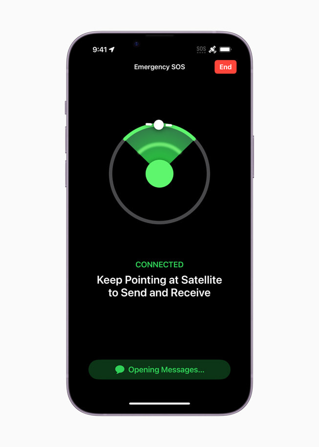
All I can say is THANK GOD that I did, because it turned into over a week long effort to get them out. Two decided to walk out and were able to text me a nav point that I was able to meet them at (took all day to get there because of the snow and mud, but I made it and was able to pick them up). The other two stayed up there, and we sent probably 100 texts back and forth coordinating what turned into like 3 solid days of fighting to get up there with snowcats and get them back down. Multiple situational changes that we would have been hosed without.
In the end, I spent like $80 on texts, but it was money well spent. I think it's great for people to have SOS built into their iPhone, but there needs to be a "use it now, pay later" or no one is going to activate it and actually have it available when they need it. The other half of the equation is that you really need to be able to send texts. The SOS button is very expensive. Extremely expensive. That will keep a lot of people from using it. (Yes insurance exists, but hardly anyone has it). Being able to text your friends for help is substantially more useful. Being stuck on a backroad with no service, 5, 10, 20 miles from where anyone can be expected to drive by is a far more common scenario than breaking your leg at the top of a mountain and needing to be evacuated.